You are here: Home > Network List > YQ13 - Study of Extension and Magmatism in Malawi and Tanzania Stations List
> Station NGON Ngonga,Malawi > Earthquake Result Viewer
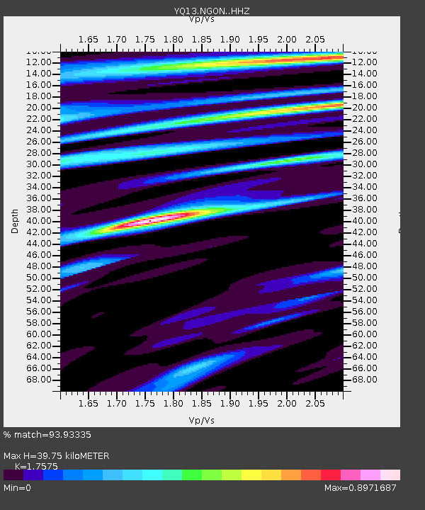
NGON Ngonga,Malawi - Earthquake Result Viewer
| Earthquake location: |
South Sandwich Islands Region |
| Earthquake latitude/longitude: |
-55.5/-28.2 |
| Earthquake time(UTC): |
2015/02/16 (047) 22:00:53 GMT |
| Earthquake Depth: |
10 km |
| Earthquake Magnitude: |
6.2 MWW, 6.7 MI |
| Earthquake Catalog/Contributor: |
NEIC PDE/NEIC COMCAT |
|
| Network: |
YQ Study of Extension and Magmatism in Malawi and Tanzania |
| Station: |
NGON Ngonga,Malawi |
| Lat/Lon: |
10.94 S/33.94 E |
| Elevation: |
1060 m |
|
| Distance: |
65.4 deg |
| Az: |
72.747 deg |
| Baz: |
213.568 deg |
| Ray Param: |
0.058270328 |
| Estimated Moho Depth: |
39.75 km |
| Estimated Crust Vp/Vs: |
1.76 |
| Assumed Crust Vp: |
6.367 km/s |
| Estimated Crust Vs: |
3.623 km/s |
| Estimated Crust Poisson's Ratio: |
0.26 |
|
| Radial Match: |
93.93335 % |
| Radial Bump: |
400 |
| Transverse Match: |
72.754135 % |
| Transverse Bump: |
400 |
| SOD ConfigId: |
7019011 |
| Insert Time: |
2019-04-16 20:43:00.518 +0000 |
| GWidth: |
2.5 |
| Max Bumps: |
400 |
| Tol: |
0.001 |
|

Signal To Noise
| Channel | StoN | STA | LTA |
| YQ:NGON: :HHZ:20150216T22:11:04.769985Z | 8.876768 | 8.4091E-7 | 9.473155E-8 |
| YQ:NGON: :HHN:20150216T22:11:04.769985Z | 2.5565164 | 2.0973023E-7 | 8.20375E-8 |
| YQ:NGON: :HHE:20150216T22:11:04.769985Z | 2.9393241 | 1.9912027E-7 | 6.774356E-8 |
| Arrivals |
| Ps | 4.9 SECOND |
| PpPs | 17 SECOND |
| PsPs/PpSs | 21 SECOND |


