You are here: Home > Network List > TA - USArray Transportable Network (new EarthScope stations) Stations List
> Station R56A Bull Pasture Mountain, McDowell, VA, USA > Earthquake Result Viewer
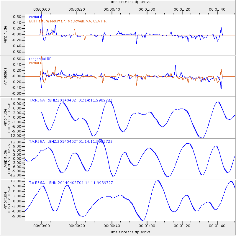
R56A Bull Pasture Mountain, McDowell, VA, USA - Earthquake Result Viewer
*The percent match for this event was below the threshold and hence no stack was calculated.
| Earthquake location: |
Off Coast Of Northern Chile |
| Earthquake latitude/longitude: |
-24.4/-72.6 |
| Earthquake time(UTC): |
2014/04/02 (092) 01:04:18 GMT |
| Earthquake Depth: |
16 km |
| Earthquake Magnitude: |
5.6 MB |
| Earthquake Catalog/Contributor: |
NEIC PDE/NEIC COMCAT |
|
| Network: |
TA USArray Transportable Network (new EarthScope stations) |
| Station: |
R56A Bull Pasture Mountain, McDowell, VA, USA |
| Lat/Lon: |
38.41 N/79.40 W |
| Elevation: |
902 m |
|
| Distance: |
62.8 deg |
| Az: |
354.005 deg |
| Baz: |
173.04 deg |
| Ray Param: |
$rayparam |
*The percent match for this event was below the threshold and hence was not used in the summary stack. |
|
| Radial Match: |
62.546207 % |
| Radial Bump: |
400 |
| Transverse Match: |
50.879192 % |
| Transverse Bump: |
400 |
| SOD ConfigId: |
626651 |
| Insert Time: |
2014-05-09 00:36:51.695 +0000 |
| GWidth: |
2.5 |
| Max Bumps: |
400 |
| Tol: |
0.001 |
|
Signal To Noise
| Channel | StoN | STA | LTA |
| TA:R56A: :BHZ:20140402T01:14:11.998972Z | 0.7956946 | 7.588656E-6 | 9.537147E-6 |
| TA:R56A: :BHN:20140402T01:14:11.998972Z | 2.3184655 | 8.671573E-6 | 3.740221E-6 |
| TA:R56A: :BHE:20140402T01:14:11.998972Z | 1.8019058 | 9.322356E-6 | 5.173609E-6 |
| Arrivals |
| Ps | |
| PpPs | |
| PsPs/PpSs | |


