You are here: Home > Network List > YQ13 - Study of Extension and Magmatism in Malawi and Tanzania Stations List
> Station THAN Thanula,Malawi > Earthquake Result Viewer
THAN Thanula,Malawi - Earthquake Result Viewer
| Earthquake location: |
South Sandwich Islands Region |
| Earthquake latitude/longitude: |
-55.5/-28.2 |
| Earthquake time(UTC): |
2015/02/16 (047) 22:00:53 GMT |
| Earthquake Depth: |
10 km |
| Earthquake Magnitude: |
6.2 MWW, 6.7 MI |
| Earthquake Catalog/Contributor: |
NEIC PDE/NEIC COMCAT |
|
| Network: |
YQ Study of Extension and Magmatism in Malawi and Tanzania |
| Station: |
THAN Thanula,Malawi |
| Lat/Lon: |
11.47 S/34.18 E |
| Elevation: |
683 m |
|
| Distance: |
65.1 deg |
| Az: |
73.285 deg |
| Baz: |
213.746 deg |
| Ray Param: |
0.058471836 |
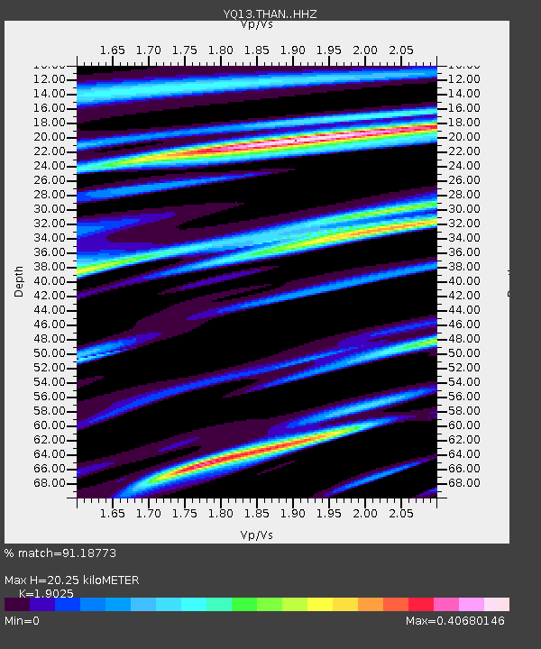
| Estimated Moho Depth: |
20.25 km |
| Estimated Crust Vp/Vs: |
1.90 |
| Assumed Crust Vp: |
6.502 km/s |
| Estimated Crust Vs: |
3.417 km/s |
| Estimated Crust Poisson's Ratio: |
0.31 |
|
| Radial Match: |
91.18773 % |
| Radial Bump: |
362 |
| Transverse Match: |
56.10258 % |
| Transverse Bump: |
400 |
| SOD ConfigId: |
7019011 |
| Insert Time: |
2019-04-16 20:43:02.689 +0000 |
| GWidth: |
2.5 |
| Max Bumps: |
400 |
| Tol: |
0.001 |
|

Signal To Noise
| Channel | StoN | STA | LTA |
| YQ:THAN: :HHZ:20150216T22:11:02.790005Z | 10.239519 | 8.9609205E-7 | 8.7513094E-8 |
| YQ:THAN: :HHN:20150216T22:11:02.790005Z | 3.0281096 | 3.3338944E-7 | 1.10098206E-7 |
| YQ:THAN: :HHE:20150216T22:11:02.790005Z | 2.7114422 | 2.8377815E-7 | 1.0465948E-7 |
| Arrivals |
| Ps | 2.9 SECOND |
| PpPs | 8.7 SECOND |
| PsPs/PpSs | 12 SECOND |


