You are here: Home > Network List > YQ13 - Study of Extension and Magmatism in Malawi and Tanzania Stations List
> Station THAZ Thazima,Malawi > Earthquake Result Viewer
THAZ Thazima,Malawi - Earthquake Result Viewer
| Earthquake location: |
South Sandwich Islands Region |
| Earthquake latitude/longitude: |
-55.5/-28.2 |
| Earthquake time(UTC): |
2015/02/16 (047) 22:00:53 GMT |
| Earthquake Depth: |
10 km |
| Earthquake Magnitude: |
6.2 MWW, 6.7 MI |
| Earthquake Catalog/Contributor: |
NEIC PDE/NEIC COMCAT |
|
| Network: |
YQ Study of Extension and Magmatism in Malawi and Tanzania |
| Station: |
THAZ Thazima,Malawi |
| Lat/Lon: |
10.83 S/33.59 E |
| Elevation: |
1695 m |
|
| Distance: |
65.3 deg |
| Az: |
72.366 deg |
| Baz: |
213.475 deg |
| Ray Param: |
0.058336284 |
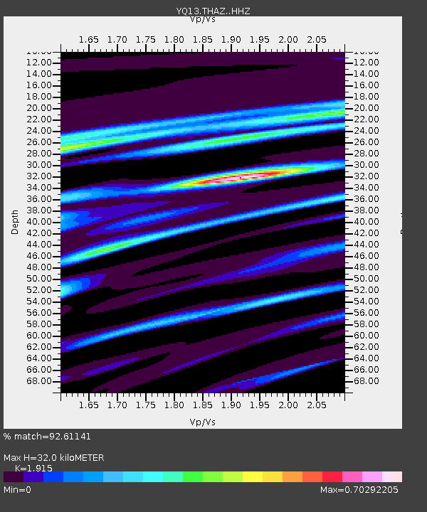
| Estimated Moho Depth: |
32.0 km |
| Estimated Crust Vp/Vs: |
1.91 |
| Assumed Crust Vp: |
6.367 km/s |
| Estimated Crust Vs: |
3.325 km/s |
| Estimated Crust Poisson's Ratio: |
0.31 |
|
| Radial Match: |
92.61141 % |
| Radial Bump: |
400 |
| Transverse Match: |
76.180786 % |
| Transverse Bump: |
400 |
| SOD ConfigId: |
7019011 |
| Insert Time: |
2019-04-16 20:43:04.557 +0000 |
| GWidth: |
2.5 |
| Max Bumps: |
400 |
| Tol: |
0.001 |
|

Signal To Noise
| Channel | StoN | STA | LTA |
| YQ:THAZ: :HHZ:20150216T22:11:04.118984Z | 11.102253 | 8.131863E-7 | 7.324516E-8 |
| YQ:THAZ: :HHN:20150216T22:11:04.118984Z | 3.9872026 | 3.178924E-7 | 7.9728174E-8 |
| YQ:THAZ: :HHE:20150216T22:11:04.118984Z | 3.359477 | 3.097758E-7 | 9.2209525E-8 |
| Arrivals |
| Ps | 4.8 SECOND |
| PpPs | 14 SECOND |
| PsPs/PpSs | 19 SECOND |


