You are here: Home > Network List > AK - Alaska Regional Network Stations List
> Station RDOG Red Dog Mine, AK, USA > Earthquake Result Viewer
RDOG Red Dog Mine, AK, USA - Earthquake Result Viewer
| Earthquake location: |
Tonga Islands |
| Earthquake latitude/longitude: |
-20.7/-174.7 |
| Earthquake time(UTC): |
2014/04/26 (116) 06:02:16 GMT |
| Earthquake Depth: |
10 km |
| Earthquake Magnitude: |
6.5 MWP |
| Earthquake Catalog/Contributor: |
NEIC PDE/NEIC COMCAT |
|
| Network: |
AK Alaska Regional Network |
| Station: |
RDOG Red Dog Mine, AK, USA |
| Lat/Lon: |
68.05 N/162.90 W |
| Elevation: |
421 m |
|
| Distance: |
88.9 deg |
| Az: |
4.398 deg |
| Baz: |
191.009 deg |
| Ray Param: |
0.04221668 |
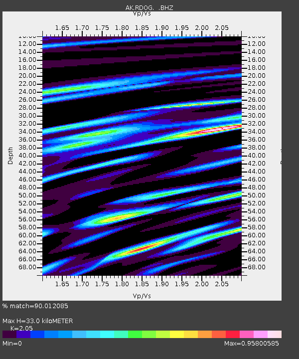
| Estimated Moho Depth: |
33.0 km |
| Estimated Crust Vp/Vs: |
2.05 |
| Assumed Crust Vp: |
5.906 km/s |
| Estimated Crust Vs: |
2.881 km/s |
| Estimated Crust Poisson's Ratio: |
0.34 |
|
| Radial Match: |
90.012085 % |
| Radial Bump: |
400 |
| Transverse Match: |
87.16453 % |
| Transverse Bump: |
390 |
| SOD ConfigId: |
626651 |
| Insert Time: |
2014-05-10 06:08:32.604 +0000 |
| GWidth: |
2.5 |
| Max Bumps: |
400 |
| Tol: |
0.001 |
|

Signal To Noise
| Channel | StoN | STA | LTA |
| AK:RDOG: :BHZ:20140426T06:14:39.447974Z | 22.703064 | 1.4939396E-6 | 6.5803434E-8 |
| AK:RDOG: :BHN:20140426T06:14:39.447974Z | 5.506186 | 4.4121487E-7 | 8.013076E-8 |
| AK:RDOG: :BHE:20140426T06:14:39.447974Z | 4.3480296 | 3.1733725E-7 | 7.298415E-8 |
| Arrivals |
| Ps | 6.0 SECOND |
| PpPs | 17 SECOND |
| PsPs/PpSs | 23 SECOND |


