You are here: Home > Network List > KN - Kyrgyz Seismic Telemetry Network Stations List
> Station TKM2 - > Earthquake Result Viewer
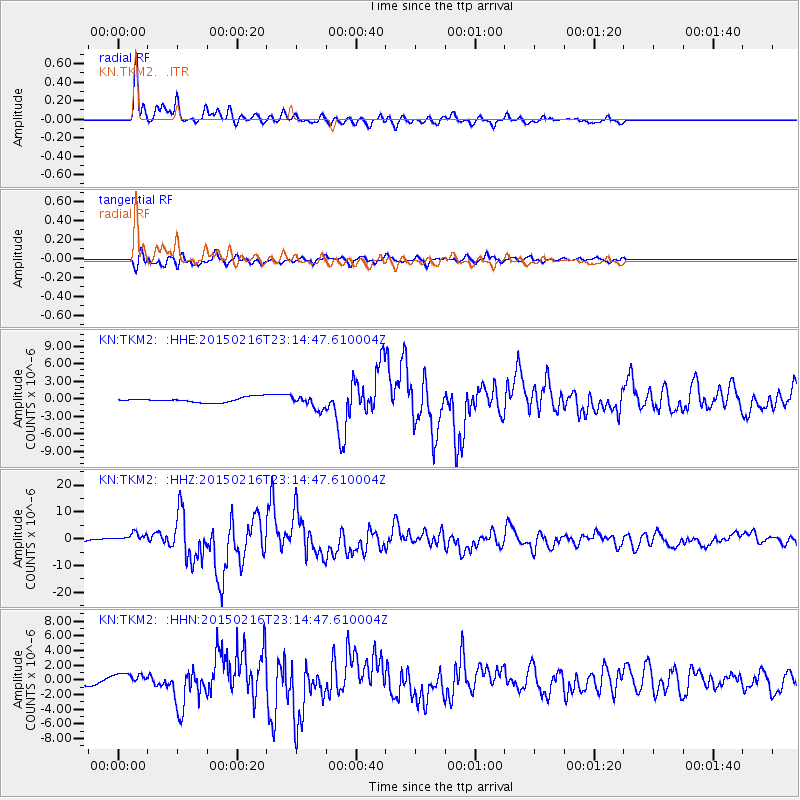
TKM2 - - Earthquake Result Viewer
*The percent match for this event was below the threshold and hence no stack was calculated.
| Earthquake location: |
Near East Coast Of Honshu, Japan |
| Earthquake latitude/longitude: |
39.8/142.9 |
| Earthquake time(UTC): |
2015/02/16 (047) 23:06:27 GMT |
| Earthquake Depth: |
23 km |
| Earthquake Magnitude: |
6.7 MWW, 6.9 MI |
| Earthquake Catalog/Contributor: |
NEIC PDE/NEIC COMCAT |
|
| Network: |
KN Kyrgyz Seismic Telemetry Network |
| Station: |
TKM2 - |
| Lat/Lon: |
42.92 N/75.60 E |
| Elevation: |
2020 m |
|
| Distance: |
49.4 deg |
| Az: |
296.754 deg |
| Baz: |
69.405 deg |
| Ray Param: |
$rayparam |
*The percent match for this event was below the threshold and hence was not used in the summary stack. |
|
| Radial Match: |
94.174515 % |
| Radial Bump: |
386 |
| Transverse Match: |
88.3913 % |
| Transverse Bump: |
400 |
| SOD ConfigId: |
7019011 |
| Insert Time: |
2019-04-16 20:47:47.168 +0000 |
| GWidth: |
2.5 |
| Max Bumps: |
400 |
| Tol: |
0.001 |
|
Signal To Noise
| Channel | StoN | STA | LTA |
| KN:TKM2: :HHZ:20150216T23:14:47.610004Z | 2.4091282 | 1.928869E-6 | 8.0065024E-7 |
| KN:TKM2: :HHN:20150216T23:14:47.610004Z | 2.3461185 | 8.414061E-7 | 3.5863752E-7 |
| KN:TKM2: :HHE:20150216T23:14:47.610004Z | 2.7633803 | 8.087667E-7 | 2.9267295E-7 |
| Arrivals |
| Ps | |
| PpPs | |
| PsPs/PpSs | |


