PFO Pinon Flat, California, USA - Earthquake Result Viewer
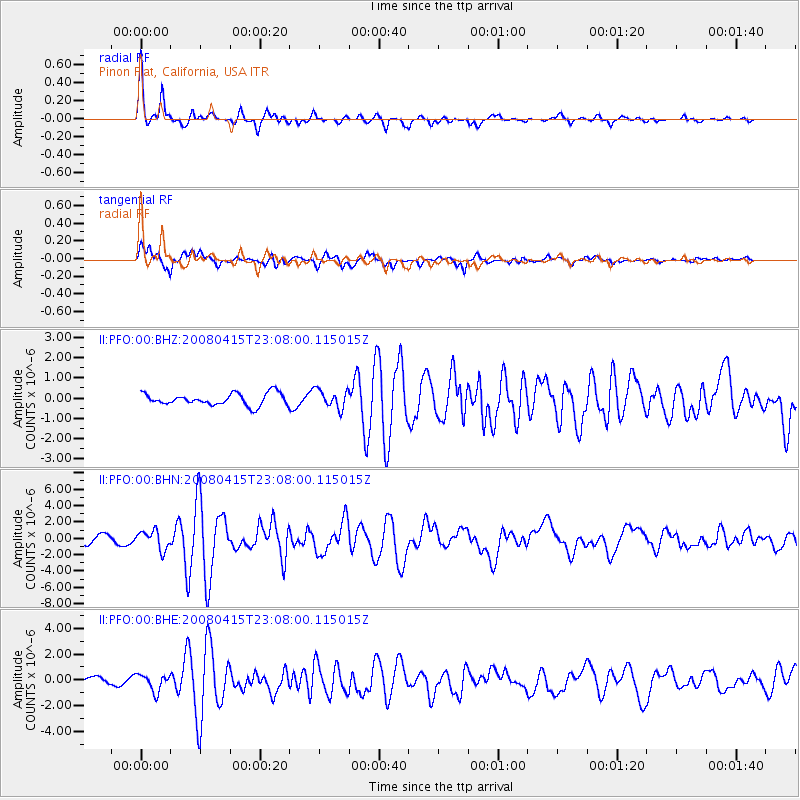
Earthquake location: Andreanof Islands, Aleutian Is.
Earthquake latitude/longitude: 51.9/-179.4
Earthquake time(UTC): 2008/04/15 (106) 22:59:51 GMT
Earthquake Depth: 10 km
Earthquake Magnitude: 6.1 MB, 6.4 MS, 6.4 MW, 6.4 MW
Earthquake Catalog/Contributor: WHDF/NEIC
Network: II Global Seismograph Network (GSN - IRIS/IDA)
Station: PFO Pinon Flat, California, USA
Lat/Lon: 33.61 N/116.46 W
Elevation: 1280 m
Distance: 48.1 deg
Az: 86.645 deg
Baz: 312.103 deg
Ray Param: 0.06958002
Estimated Moho Depth: 29.5 km
Estimated Crust Vp/Vs: 1.74
Assumed Crust Vp: 6.264 km/s
Estimated Crust Vs: 3.61 km/s
Estimated Crust Poisson's Ratio: 0.25
Radial Match: 94.431816 %
Radial Bump: 400
Transverse Match: 74.76748 %
Transverse Bump: 400
SOD ConfigId: 2504
Insert Time: 2010-03-01 21:31:58.224 +0000
GWidth: 2.5
Max Bumps: 400
Tol: 0.001

Signal To Noise

ChannelStoNSTALTA
II:PFO:00:BHN:20080415T23:08:00.115015Z2.76098011.1521191E-64.1728626E-7
II:PFO:00:BHE:20080415T23:08:00.115015Z1.97786316.544844E-73.309048E-7
II:PFO:00:BHZ:20080415T23:08:00.115015Z1.56555244.5817131E-72.9265794E-7
Arrivals
Ps3.7 SECOND
PpPs12 SECOND
PsPs/PpSs16 SECOND