You are here: Home > Network List > AZ - ANZA Regional Network Stations List
> Station LVA2 AZ.LVA2 > Earthquake Result Viewer
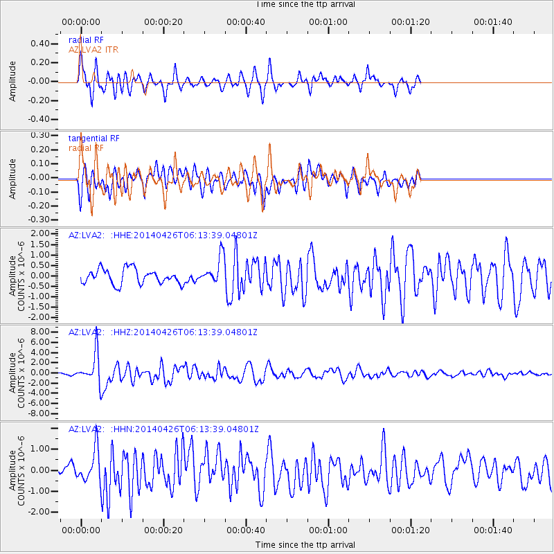
LVA2 AZ.LVA2 - Earthquake Result Viewer
*The percent match for this event was below the threshold and hence no stack was calculated.
| Earthquake location: |
Tonga Islands |
| Earthquake latitude/longitude: |
-20.7/-174.7 |
| Earthquake time(UTC): |
2014/04/26 (116) 06:02:16 GMT |
| Earthquake Depth: |
10 km |
| Earthquake Magnitude: |
6.5 MWP |
| Earthquake Catalog/Contributor: |
NEIC PDE/NEIC COMCAT |
|
| Network: |
AZ ANZA Regional Network |
| Station: |
LVA2 AZ.LVA2 |
| Lat/Lon: |
33.35 N/116.56 W |
| Elevation: |
1435 m |
|
| Distance: |
77.2 deg |
| Az: |
46.784 deg |
| Baz: |
234.596 deg |
| Ray Param: |
$rayparam |
*The percent match for this event was below the threshold and hence was not used in the summary stack. |
|
| Radial Match: |
78.87334 % |
| Radial Bump: |
390 |
| Transverse Match: |
73.43305 % |
| Transverse Bump: |
400 |
| SOD ConfigId: |
626651 |
| Insert Time: |
2014-05-10 06:14:12.282 +0000 |
| GWidth: |
2.5 |
| Max Bumps: |
400 |
| Tol: |
0.001 |
|
Signal To Noise
| Channel | StoN | STA | LTA |
| AZ:LVA2: :HHZ:20140426T06:13:39.04801Z | 13.866807 | 3.0814645E-6 | 2.2221874E-7 |
| AZ:LVA2: :HHN:20140426T06:13:39.04801Z | 3.6029058 | 8.1753916E-7 | 2.2691104E-7 |
| AZ:LVA2: :HHE:20140426T06:13:39.04801Z | 1.9448384 | 6.881826E-7 | 3.5385077E-7 |
| Arrivals |
| Ps | |
| PpPs | |
| PsPs/PpSs | |


