You are here: Home > Network List > TA - USArray Transportable Network (new EarthScope stations) Stations List
> Station G59A Clarenceville, QC, USA > Earthquake Result Viewer
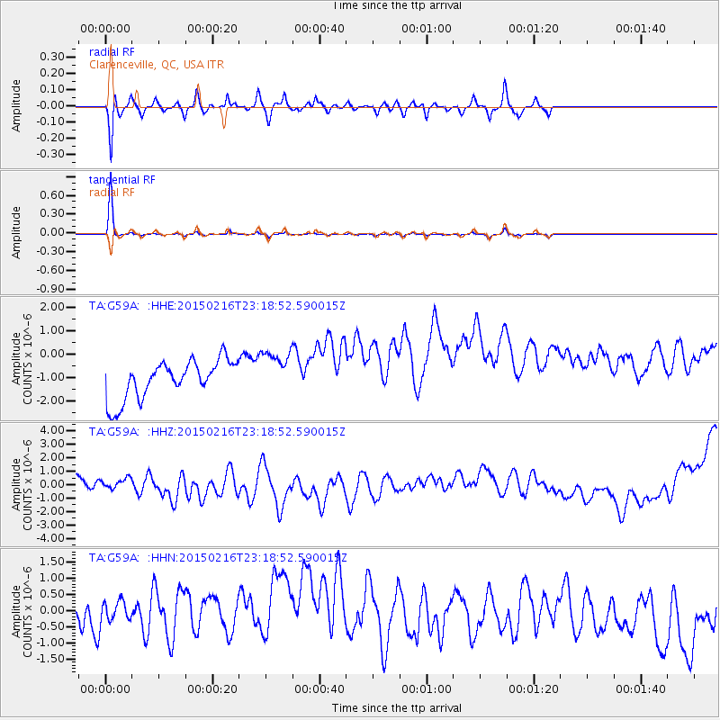
G59A Clarenceville, QC, USA - Earthquake Result Viewer
*The percent match for this event was below the threshold and hence no stack was calculated.
| Earthquake location: |
Near East Coast Of Honshu, Japan |
| Earthquake latitude/longitude: |
39.8/142.9 |
| Earthquake time(UTC): |
2015/02/16 (047) 23:06:27 GMT |
| Earthquake Depth: |
23 km |
| Earthquake Magnitude: |
6.7 MWW, 6.9 MI |
| Earthquake Catalog/Contributor: |
NEIC PDE/NEIC COMCAT |
|
| Network: |
TA USArray Transportable Network (new EarthScope stations) |
| Station: |
G59A Clarenceville, QC, USA |
| Lat/Lon: |
45.08 N/73.18 W |
| Elevation: |
36 m |
|
| Distance: |
89.5 deg |
| Az: |
24.656 deg |
| Baz: |
333.037 deg |
| Ray Param: |
$rayparam |
*The percent match for this event was below the threshold and hence was not used in the summary stack. |
|
| Radial Match: |
73.85651 % |
| Radial Bump: |
400 |
| Transverse Match: |
97.74021 % |
| Transverse Bump: |
103 |
| SOD ConfigId: |
7019011 |
| Insert Time: |
2019-04-16 20:50:08.441 +0000 |
| GWidth: |
2.5 |
| Max Bumps: |
400 |
| Tol: |
0.001 |
|
Signal To Noise
| Channel | StoN | STA | LTA |
| TA:G59A: :HHZ:20150216T23:18:52.590015Z | 1.2131175 | 1.320035E-6 | 1.0881345E-6 |
| TA:G59A: :HHN:20150216T23:18:52.590015Z | 1.5951604 | 7.6483775E-7 | 4.794739E-7 |
| TA:G59A: :HHE:20150216T23:18:52.590015Z | 1.1754464 | 9.736486E-7 | 8.2832247E-7 |
| Arrivals |
| Ps | |
| PpPs | |
| PsPs/PpSs | |


