You are here: Home > Network List > II - Global Seismograph Network (GSN - IRIS/IDA) Stations List
> Station PFO Pinon Flat, California, USA > Earthquake Result Viewer
PFO Pinon Flat, California, USA - Earthquake Result Viewer

| Earthquake location: |
Sea Of Okhotsk |
| Earthquake latitude/longitude: |
53.9/152.9 |
| Earthquake time(UTC): |
2008/07/05 (187) 02:12:04 GMT |
| Earthquake Depth: |
633 km |
| Earthquake Magnitude: |
6.8 MB, 7.7 MW, 7.7 MW |
| Earthquake Catalog/Contributor: |
WHDF/NEIC |
|
| Network: |
II Global Seismograph Network (GSN - IRIS/IDA) |
| Station: |
PFO Pinon Flat, California, USA |
| Lat/Lon: |
33.61 N/116.46 W |
| Elevation: |
1280 m |
|
| Distance: |
64.0 deg |
| Az: |
68.191 deg |
| Baz: |
318.803 deg |
| Ray Param: |
0.056763828 |
| Estimated Moho Depth: |
29.0 km |
| Estimated Crust Vp/Vs: |
1.72 |
| Assumed Crust Vp: |
6.264 km/s |
| Estimated Crust Vs: |
3.636 km/s |
| Estimated Crust Poisson's Ratio: |
0.25 |
|
| Radial Match: |
95.655914 % |
| Radial Bump: |
400 |
| Transverse Match: |
87.47624 % |
| Transverse Bump: |
400 |
| SOD ConfigId: |
2504 |
| Insert Time: |
2010-03-01 21:32:09.441 +0000 |
| GWidth: |
2.5 |
| Max Bumps: |
400 |
| Tol: |
0.001 |
|
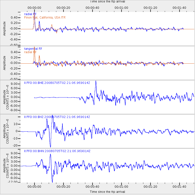
Signal To Noise
| Channel | StoN | STA | LTA |
| II:PFO:00:BHZ:20080705T02:21:06.969014Z | 29.568472 | 4.153067E-6 | 1.4045592E-7 |
| II:PFO:00:BHN:20080705T02:21:06.969014Z | 19.79044 | 1.6387216E-6 | 8.28037E-8 |
| II:PFO:00:BHE:20080705T02:21:06.969014Z | 10.29889 | 1.238874E-6 | 1.2029199E-7 |
| Arrivals |
| Ps | 3.5 SECOND |
| PpPs | 12 SECOND |
| PsPs/PpSs | 16 SECOND |


