You are here: Home > Network List > IU - Global Seismograph Network (GSN - IRIS/USGS) Stations List
> Station POHA Pohakuloa, Hawaii, USA > Earthquake Result Viewer
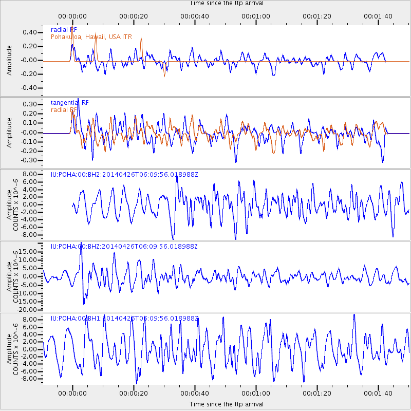
POHA Pohakuloa, Hawaii, USA - Earthquake Result Viewer
*The percent match for this event was below the threshold and hence no stack was calculated.
| Earthquake location: |
Tonga Islands |
| Earthquake latitude/longitude: |
-20.7/-174.7 |
| Earthquake time(UTC): |
2014/04/26 (116) 06:02:16 GMT |
| Earthquake Depth: |
10 km |
| Earthquake Magnitude: |
6.5 MWP |
| Earthquake Catalog/Contributor: |
NEIC PDE/NEIC COMCAT |
|
| Network: |
IU Global Seismograph Network (GSN - IRIS/USGS) |
| Station: |
POHA Pohakuloa, Hawaii, USA |
| Lat/Lon: |
19.76 N/155.53 W |
| Elevation: |
1990 m |
|
| Distance: |
44.4 deg |
| Az: |
26.205 deg |
| Baz: |
206.033 deg |
| Ray Param: |
$rayparam |
*The percent match for this event was below the threshold and hence was not used in the summary stack. |
|
| Radial Match: |
50.642067 % |
| Radial Bump: |
400 |
| Transverse Match: |
60.593285 % |
| Transverse Bump: |
400 |
| SOD ConfigId: |
626651 |
| Insert Time: |
2014-05-10 06:23:01.191 +0000 |
| GWidth: |
2.5 |
| Max Bumps: |
400 |
| Tol: |
0.001 |
|
Signal To Noise
| Channel | StoN | STA | LTA |
| IU:POHA:00:BHZ:20140426T06:09:56.018988Z | 5.681609 | 9.2612345E-6 | 1.6300372E-6 |
| IU:POHA:00:BH1:20140426T06:09:56.018988Z | 1.7845063 | 4.9756336E-6 | 2.7882409E-6 |
| IU:POHA:00:BH2:20140426T06:09:56.018988Z | 1.7543224 | 4.7164135E-6 | 2.688453E-6 |
| Arrivals |
| Ps | |
| PpPs | |
| PsPs/PpSs | |


