You are here: Home > Network List > TA - USArray Transportable Network (new EarthScope stations) Stations List
> Station W56A Indian Trail, NC, USA > Earthquake Result Viewer
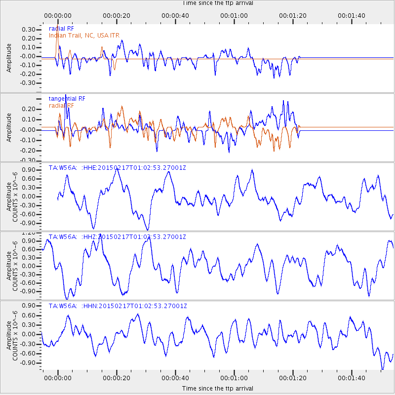
W56A Indian Trail, NC, USA - Earthquake Result Viewer
*The percent match for this event was below the threshold and hence no stack was calculated.
| Earthquake location: |
Off East Coast Of Honshu, Japan |
| Earthquake latitude/longitude: |
39.9/143.3 |
| Earthquake time(UTC): |
2015/02/17 (048) 00:50:02 GMT |
| Earthquake Depth: |
10 km |
| Earthquake Magnitude: |
4.6 mb |
| Earthquake Catalog/Contributor: |
ISC/ISC |
|
| Network: |
TA USArray Transportable Network (new EarthScope stations) |
| Station: |
W56A Indian Trail, NC, USA |
| Lat/Lon: |
35.13 N/80.58 W |
| Elevation: |
177 m |
|
| Distance: |
95.1 deg |
| Az: |
34.808 deg |
| Baz: |
327.6 deg |
| Ray Param: |
$rayparam |
*The percent match for this event was below the threshold and hence was not used in the summary stack. |
|
| Radial Match: |
57.29095 % |
| Radial Bump: |
400 |
| Transverse Match: |
51.1152 % |
| Transverse Bump: |
400 |
| SOD ConfigId: |
7019011 |
| Insert Time: |
2019-04-16 21:00:55.301 +0000 |
| GWidth: |
2.5 |
| Max Bumps: |
400 |
| Tol: |
0.001 |
|
Signal To Noise
| Channel | StoN | STA | LTA |
| TA:W56A: :HHZ:20150217T01:02:53.27001Z | 1.8141977 | 6.7950793E-7 | 3.7455013E-7 |
| TA:W56A: :HHN:20150217T01:02:53.27001Z | 1.0826921 | 3.6948842E-7 | 3.4126822E-7 |
| TA:W56A: :HHE:20150217T01:02:53.27001Z | 1.4753187 | 6.751098E-7 | 4.576027E-7 |
| Arrivals |
| Ps | |
| PpPs | |
| PsPs/PpSs | |


