You are here: Home > Network List > II - Global Seismograph Network (GSN - IRIS/IDA) Stations List
> Station PFO Pinon Flat, California, USA > Earthquake Result Viewer
PFO Pinon Flat, California, USA - Earthquake Result Viewer

| Earthquake location: |
Samoa Islands Region |
| Earthquake latitude/longitude: |
-16.5/-172.4 |
| Earthquake time(UTC): |
1992/05/12 (133) 18:05:45 GMT |
| Earthquake Depth: |
33 km |
| Earthquake Magnitude: |
6.3 MB, 6.8 MS |
| Earthquake Catalog/Contributor: |
WHDF/NEIC |
|
| Network: |
II Global Seismograph Network (GSN - IRIS/IDA) |
| Station: |
PFO Pinon Flat, California, USA |
| Lat/Lon: |
33.61 N/116.46 W |
| Elevation: |
1280 m |
|
| Distance: |
73.0 deg |
| Az: |
46.331 deg |
| Baz: |
236.274 deg |
| Ray Param: |
0.053274028 |
| Estimated Moho Depth: |
29.5 km |
| Estimated Crust Vp/Vs: |
1.63 |
| Assumed Crust Vp: |
6.264 km/s |
| Estimated Crust Vs: |
3.849 km/s |
| Estimated Crust Poisson's Ratio: |
0.20 |
|
| Radial Match: |
94.838684 % |
| Radial Bump: |
400 |
| Transverse Match: |
86.43373 % |
| Transverse Bump: |
400 |
| SOD ConfigId: |
61242 |
| Insert Time: |
2010-03-01 21:32:36.751 +0000 |
| GWidth: |
2.5 |
| Max Bumps: |
400 |
| Tol: |
0.001 |
|
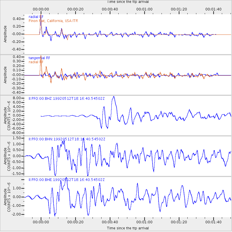
Signal To Noise
| Channel | StoN | STA | LTA |
| II:PFO:00:BHN:19920512T18:16:40.54502Z | 1.748806 | 2.0588652E-7 | 1.1772977E-7 |
| II:PFO:00:BHE:19920512T18:16:40.54502Z | 2.0058749 | 3.6788472E-7 | 1.8340363E-7 |
| II:PFO:00:BHZ:19920512T18:16:40.54502Z | 9.054288 | 1.4341467E-6 | 1.5839422E-7 |
| Arrivals |
| Ps | 3.1 SECOND |
| PpPs | 12 SECOND |
| PsPs/PpSs | 15 SECOND |


