You are here: Home > Network List > TA - USArray Transportable Network (new EarthScope stations) Stations List
> Station J01E Myrtle Point, OR, USA > Earthquake Result Viewer
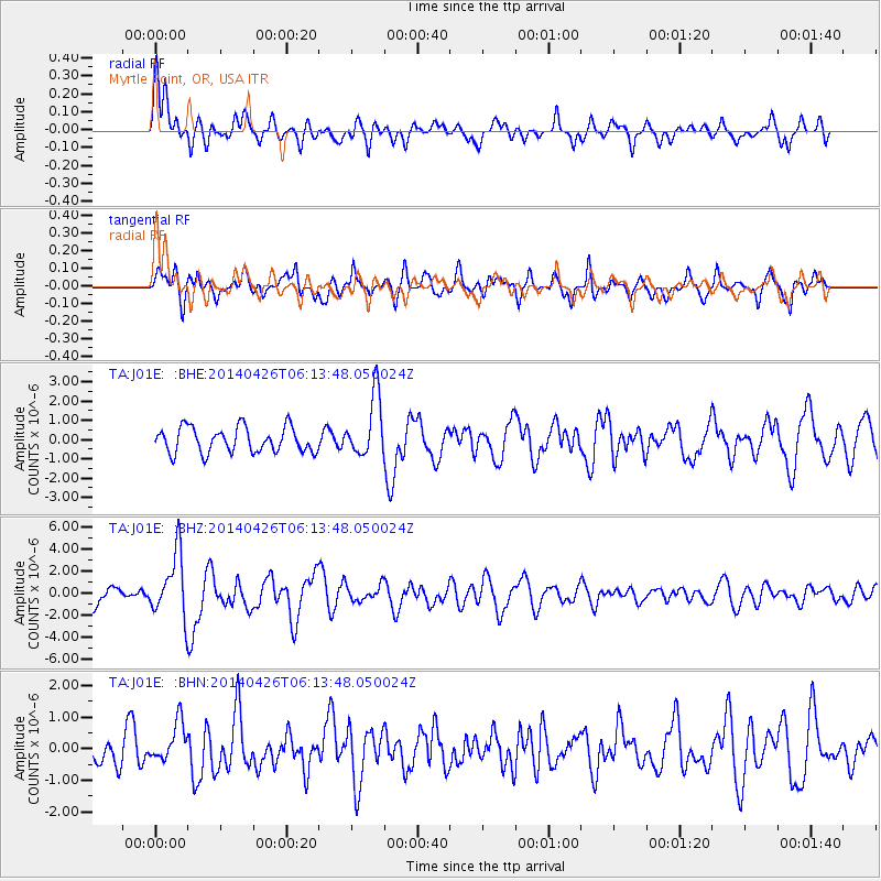
J01E Myrtle Point, OR, USA - Earthquake Result Viewer
*The percent match for this event was below the threshold and hence no stack was calculated.
| Earthquake location: |
Tonga Islands |
| Earthquake latitude/longitude: |
-20.7/-174.7 |
| Earthquake time(UTC): |
2014/04/26 (116) 06:02:16 GMT |
| Earthquake Depth: |
10 km |
| Earthquake Magnitude: |
6.5 MWP |
| Earthquake Catalog/Contributor: |
NEIC PDE/NEIC COMCAT |
|
| Network: |
TA USArray Transportable Network (new EarthScope stations) |
| Station: |
J01E Myrtle Point, OR, USA |
| Lat/Lon: |
43.16 N/123.93 W |
| Elevation: |
128 m |
|
| Distance: |
78.8 deg |
| Az: |
35.276 deg |
| Baz: |
227.633 deg |
| Ray Param: |
$rayparam |
*The percent match for this event was below the threshold and hence was not used in the summary stack. |
|
| Radial Match: |
77.81174 % |
| Radial Bump: |
400 |
| Transverse Match: |
69.578606 % |
| Transverse Bump: |
400 |
| SOD ConfigId: |
626651 |
| Insert Time: |
2014-05-10 06:34:32.365 +0000 |
| GWidth: |
2.5 |
| Max Bumps: |
400 |
| Tol: |
0.001 |
|
Signal To Noise
| Channel | StoN | STA | LTA |
| TA:J01E: :BHZ:20140426T06:13:48.050024Z | 3.224271 | 2.8522134E-6 | 8.846072E-7 |
| TA:J01E: :BHN:20140426T06:13:48.050024Z | 1.107467 | 6.3286075E-7 | 5.714488E-7 |
| TA:J01E: :BHE:20140426T06:13:48.050024Z | 2.435408 | 1.5935624E-6 | 6.5433073E-7 |
| Arrivals |
| Ps | |
| PpPs | |
| PsPs/PpSs | |


