You are here: Home > Network List > TA - USArray Transportable Network (new EarthScope stations) Stations List
> Station MDND Maddock, ND, USA > Earthquake Result Viewer
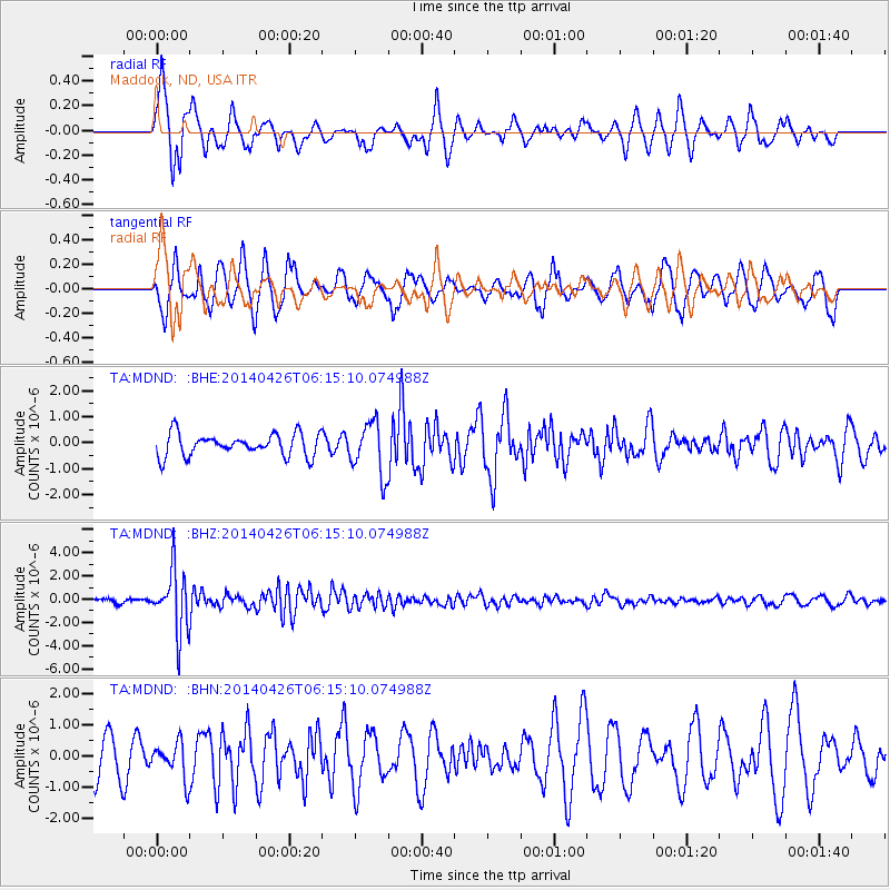
MDND Maddock, ND, USA - Earthquake Result Viewer
*The percent match for this event was below the threshold and hence no stack was calculated.
| Earthquake location: |
Tonga Islands |
| Earthquake latitude/longitude: |
-20.7/-174.7 |
| Earthquake time(UTC): |
2014/04/26 (116) 06:02:16 GMT |
| Earthquake Depth: |
10 km |
| Earthquake Magnitude: |
6.5 MWP |
| Earthquake Catalog/Contributor: |
NEIC PDE/NEIC COMCAT |
|
| Network: |
TA USArray Transportable Network (new EarthScope stations) |
| Station: |
MDND Maddock, ND, USA |
| Lat/Lon: |
47.85 N/99.60 W |
| Elevation: |
479 m |
|
| Distance: |
95.6 deg |
| Az: |
40.84 deg |
| Baz: |
245.347 deg |
| Ray Param: |
$rayparam |
*The percent match for this event was below the threshold and hence was not used in the summary stack. |
|
| Radial Match: |
77.19079 % |
| Radial Bump: |
337 |
| Transverse Match: |
58.103317 % |
| Transverse Bump: |
400 |
| SOD ConfigId: |
626651 |
| Insert Time: |
2014-05-10 06:35:09.276 +0000 |
| GWidth: |
2.5 |
| Max Bumps: |
400 |
| Tol: |
0.001 |
|
Signal To Noise
| Channel | StoN | STA | LTA |
| TA:MDND: :BHZ:20140426T06:15:10.074988Z | 13.457694 | 2.6197035E-6 | 1.9466215E-7 |
| TA:MDND: :BHN:20140426T06:15:10.074988Z | 0.7559735 | 5.662072E-7 | 7.489775E-7 |
| TA:MDND: :BHE:20140426T06:15:10.074988Z | 2.3589845 | 1.009631E-6 | 4.279939E-7 |
| Arrivals |
| Ps | |
| PpPs | |
| PsPs/PpSs | |


