You are here: Home > Network List > TA - USArray Transportable Network (new EarthScope stations) Stations List
> Station N02D Trinity Center, CA, USA > Earthquake Result Viewer
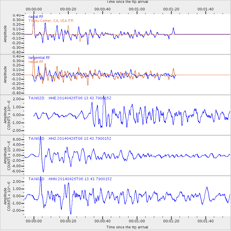
N02D Trinity Center, CA, USA - Earthquake Result Viewer
*The percent match for this event was below the threshold and hence no stack was calculated.
| Earthquake location: |
Tonga Islands |
| Earthquake latitude/longitude: |
-20.7/-174.7 |
| Earthquake time(UTC): |
2014/04/26 (116) 06:02:16 GMT |
| Earthquake Depth: |
10 km |
| Earthquake Magnitude: |
6.5 MWP |
| Earthquake Catalog/Contributor: |
NEIC PDE/NEIC COMCAT |
|
| Network: |
TA USArray Transportable Network (new EarthScope stations) |
| Station: |
N02D Trinity Center, CA, USA |
| Lat/Lon: |
40.97 N/122.71 W |
| Elevation: |
937 m |
|
| Distance: |
78.1 deg |
| Az: |
37.561 deg |
| Baz: |
228.91 deg |
| Ray Param: |
$rayparam |
*The percent match for this event was below the threshold and hence was not used in the summary stack. |
|
| Radial Match: |
75.6686 % |
| Radial Bump: |
400 |
| Transverse Match: |
82.002525 % |
| Transverse Bump: |
400 |
| SOD ConfigId: |
626651 |
| Insert Time: |
2014-05-10 06:35:16.835 +0000 |
| GWidth: |
2.5 |
| Max Bumps: |
400 |
| Tol: |
0.001 |
|
Signal To Noise
| Channel | StoN | STA | LTA |
| TA:N02D: :HHZ:20140426T06:13:43.790015Z | 6.1710744 | 2.4661576E-6 | 3.996318E-7 |
| TA:N02D: :HHN:20140426T06:13:43.790015Z | 3.3461587 | 9.66284E-7 | 2.887741E-7 |
| TA:N02D: :HHE:20140426T06:13:43.790015Z | 3.0028048 | 6.34554E-7 | 2.1132043E-7 |
| Arrivals |
| Ps | |
| PpPs | |
| PsPs/PpSs | |


