You are here: Home > Network List > TA - USArray Transportable Network (new EarthScope stations) Stations List
> Station SUSD Miller, SD, USA > Earthquake Result Viewer
SUSD Miller, SD, USA - Earthquake Result Viewer
| Earthquake location: |
Tonga Islands |
| Earthquake latitude/longitude: |
-20.7/-174.7 |
| Earthquake time(UTC): |
2014/04/26 (116) 06:02:16 GMT |
| Earthquake Depth: |
10 km |
| Earthquake Magnitude: |
6.5 MWP |
| Earthquake Catalog/Contributor: |
NEIC PDE/NEIC COMCAT |
|
| Network: |
TA USArray Transportable Network (new EarthScope stations) |
| Station: |
SUSD Miller, SD, USA |
| Lat/Lon: |
44.44 N/98.96 W |
| Elevation: |
520 m |
|
| Distance: |
94.6 deg |
| Az: |
44.138 deg |
| Baz: |
245.519 deg |
| Ray Param: |
0.041008167 |
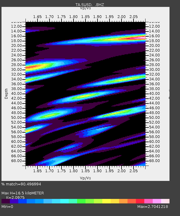
| Estimated Moho Depth: |
16.5 km |
| Estimated Crust Vp/Vs: |
2.10 |
| Assumed Crust Vp: |
6.53 km/s |
| Estimated Crust Vs: |
3.113 km/s |
| Estimated Crust Poisson's Ratio: |
0.35 |
|
| Radial Match: |
90.496994 % |
| Radial Bump: |
372 |
| Transverse Match: |
81.29904 % |
| Transverse Bump: |
370 |
| SOD ConfigId: |
626651 |
| Insert Time: |
2014-05-10 06:35:44.923 +0000 |
| GWidth: |
2.5 |
| Max Bumps: |
400 |
| Tol: |
0.001 |
|

Signal To Noise
| Channel | StoN | STA | LTA |
| TA:SUSD: :BHZ:20140426T06:15:05.525Z | 12.205785 | 2.214948E-6 | 1.8146706E-7 |
| TA:SUSD: :BHN:20140426T06:15:05.525Z | 3.2157183 | 9.0772664E-7 | 2.8227802E-7 |
| TA:SUSD: :BHE:20140426T06:15:05.525Z | 6.6125855 | 1.7097619E-6 | 2.5856178E-7 |
| Arrivals |
| Ps | 2.8 SECOND |
| PpPs | 7.7 SECOND |
| PsPs/PpSs | 11 SECOND |


