You are here: Home > Network List > TA - USArray Transportable Network (new EarthScope stations) Stations List
> Station T25A Trinidad, CO, USA > Earthquake Result Viewer
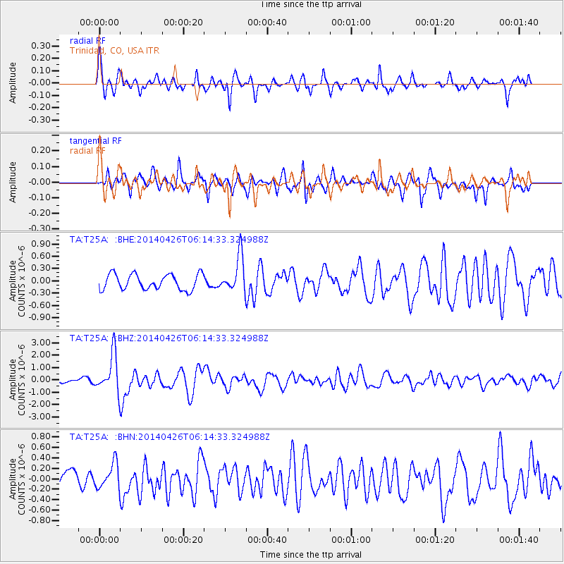
T25A Trinidad, CO, USA - Earthquake Result Viewer
*The percent match for this event was below the threshold and hence no stack was calculated.
| Earthquake location: |
Tonga Islands |
| Earthquake latitude/longitude: |
-20.7/-174.7 |
| Earthquake time(UTC): |
2014/04/26 (116) 06:02:16 GMT |
| Earthquake Depth: |
10 km |
| Earthquake Magnitude: |
6.5 MWP |
| Earthquake Catalog/Contributor: |
NEIC PDE/NEIC COMCAT |
|
| Network: |
TA USArray Transportable Network (new EarthScope stations) |
| Station: |
T25A Trinidad, CO, USA |
| Lat/Lon: |
37.14 N/104.41 W |
| Elevation: |
2017 m |
|
| Distance: |
87.6 deg |
| Az: |
48.835 deg |
| Baz: |
241.869 deg |
| Ray Param: |
$rayparam |
*The percent match for this event was below the threshold and hence was not used in the summary stack. |
|
| Radial Match: |
72.88168 % |
| Radial Bump: |
400 |
| Transverse Match: |
68.00114 % |
| Transverse Bump: |
400 |
| SOD ConfigId: |
626651 |
| Insert Time: |
2014-05-10 06:35:46.543 +0000 |
| GWidth: |
2.5 |
| Max Bumps: |
400 |
| Tol: |
0.001 |
|
Signal To Noise
| Channel | StoN | STA | LTA |
| TA:T25A: :BHZ:20140426T06:14:33.324988Z | 13.356162 | 1.5811075E-6 | 1.1838038E-7 |
| TA:T25A: :BHN:20140426T06:14:33.324988Z | 1.039287 | 2.463016E-7 | 2.3699094E-7 |
| TA:T25A: :BHE:20140426T06:14:33.324988Z | 2.4223561 | 4.5767615E-7 | 1.8893842E-7 |
| Arrivals |
| Ps | |
| PpPs | |
| PsPs/PpSs | |


