You are here: Home > Network List > TA - USArray Transportable Network (new EarthScope stations) Stations List
> Station Z41A Richland Creek Farm, El Dorado, AR, USA > Earthquake Result Viewer
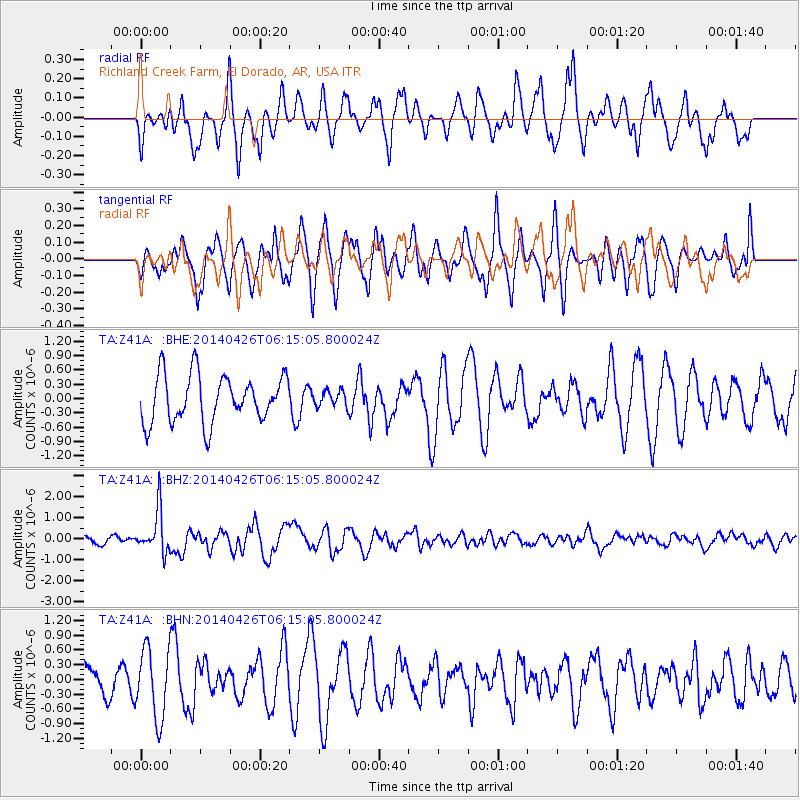
Z41A Richland Creek Farm, El Dorado, AR, USA - Earthquake Result Viewer
*The percent match for this event was below the threshold and hence no stack was calculated.
| Earthquake location: |
Tonga Islands |
| Earthquake latitude/longitude: |
-20.7/-174.7 |
| Earthquake time(UTC): |
2014/04/26 (116) 06:02:16 GMT |
| Earthquake Depth: |
10 km |
| Earthquake Magnitude: |
6.5 MWP |
| Earthquake Catalog/Contributor: |
NEIC PDE/NEIC COMCAT |
|
| Network: |
TA USArray Transportable Network (new EarthScope stations) |
| Station: |
Z41A Richland Creek Farm, El Dorado, AR, USA |
| Lat/Lon: |
33.26 N/92.80 W |
| Elevation: |
62 m |
|
| Distance: |
94.6 deg |
| Az: |
56.327 deg |
| Baz: |
248.399 deg |
| Ray Param: |
$rayparam |
*The percent match for this event was below the threshold and hence was not used in the summary stack. |
|
| Radial Match: |
64.416306 % |
| Radial Bump: |
400 |
| Transverse Match: |
66.08056 % |
| Transverse Bump: |
400 |
| SOD ConfigId: |
626651 |
| Insert Time: |
2014-05-10 06:36:31.418 +0000 |
| GWidth: |
2.5 |
| Max Bumps: |
400 |
| Tol: |
0.001 |
|
Signal To Noise
| Channel | StoN | STA | LTA |
| TA:Z41A: :BHZ:20140426T06:15:05.800024Z | 4.1310205 | 1.0059673E-6 | 2.4351544E-7 |
| TA:Z41A: :BHN:20140426T06:15:05.800024Z | 1.6698277 | 7.1150816E-7 | 4.2609676E-7 |
| TA:Z41A: :BHE:20140426T06:15:05.800024Z | 0.33012158 | 1.6269212E-7 | 4.928248E-7 |
| Arrivals |
| Ps | |
| PpPs | |
| PsPs/PpSs | |


