You are here: Home > Network List > II - Global Seismograph Network (GSN - IRIS/IDA) Stations List
> Station PFO Pinon Flat, California, USA > Earthquake Result Viewer
PFO Pinon Flat, California, USA - Earthquake Result Viewer

| Earthquake location: |
Near Coast Of Nicaragua |
| Earthquake latitude/longitude: |
11.8/-87.4 |
| Earthquake time(UTC): |
1992/09/02 (246) 00:15:57 GMT |
| Earthquake Depth: |
10 km |
| Earthquake Magnitude: |
5.3 MB, 7.2 MS |
| Earthquake Catalog/Contributor: |
WHDF/NEIC |
|
| Network: |
II Global Seismograph Network (GSN - IRIS/IDA) |
| Station: |
PFO Pinon Flat, California, USA |
| Lat/Lon: |
33.61 N/116.46 W |
| Elevation: |
1280 m |
|
| Distance: |
34.3 deg |
| Az: |
314.044 deg |
| Baz: |
122.492 deg |
| Ray Param: |
0.07781106 |
| Estimated Moho Depth: |
34.75 km |
| Estimated Crust Vp/Vs: |
1.81 |
| Assumed Crust Vp: |
6.264 km/s |
| Estimated Crust Vs: |
3.465 km/s |
| Estimated Crust Poisson's Ratio: |
0.28 |
|
| Radial Match: |
97.26258 % |
| Radial Bump: |
169 |
| Transverse Match: |
81.24528 % |
| Transverse Bump: |
400 |
| SOD ConfigId: |
61242 |
| Insert Time: |
2010-03-01 21:33:02.581 +0000 |
| GWidth: |
2.5 |
| Max Bumps: |
400 |
| Tol: |
0.001 |
|
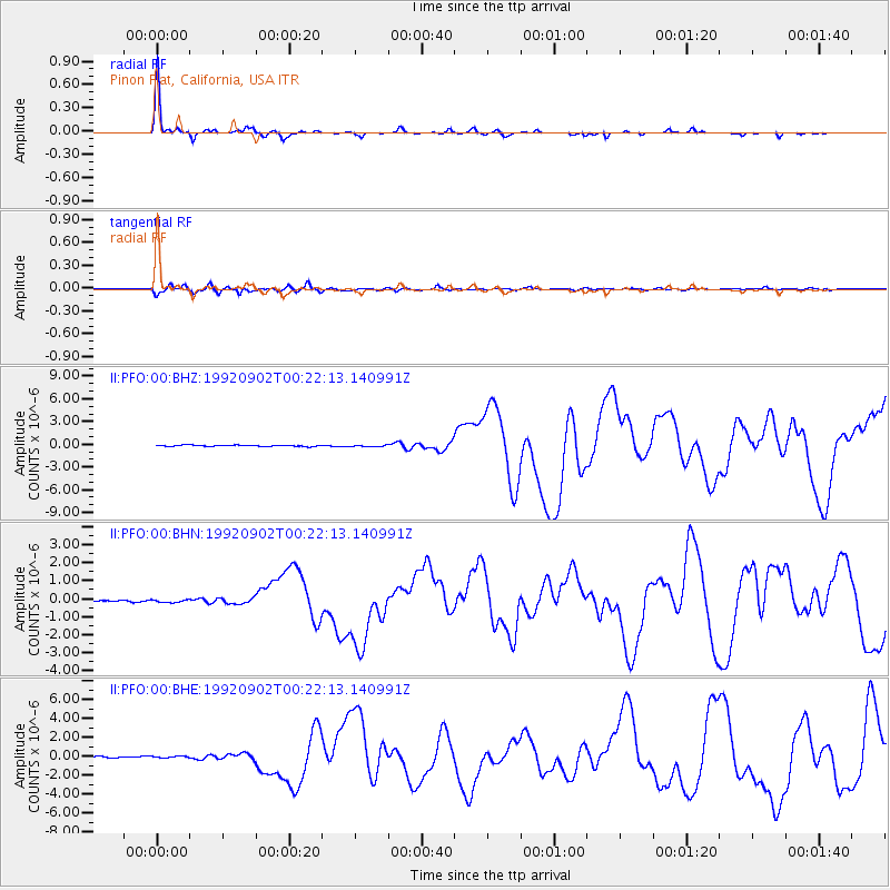
Signal To Noise
| Channel | StoN | STA | LTA |
| II:PFO:00:BHN:19920902T00:22:13.140991Z | 1.1202216 | 7.68611E-8 | 6.86124E-8 |
| II:PFO:00:BHE:19920902T00:22:13.140991Z | 1.6738464 | 9.677789E-8 | 5.7817665E-8 |
| II:PFO:00:BHZ:19920902T00:22:13.140991Z | 1.3444982 | 1.0163238E-7 | 7.5591316E-8 |
| Arrivals |
| Ps | 4.8 SECOND |
| PpPs | 15 SECOND |
| PsPs/PpSs | 19 SECOND |


