You are here: Home > Network List > IU - Global Seismograph Network (GSN - IRIS/USGS) Stations List
> Station POHA Pohakuloa, Hawaii, USA > Earthquake Result Viewer
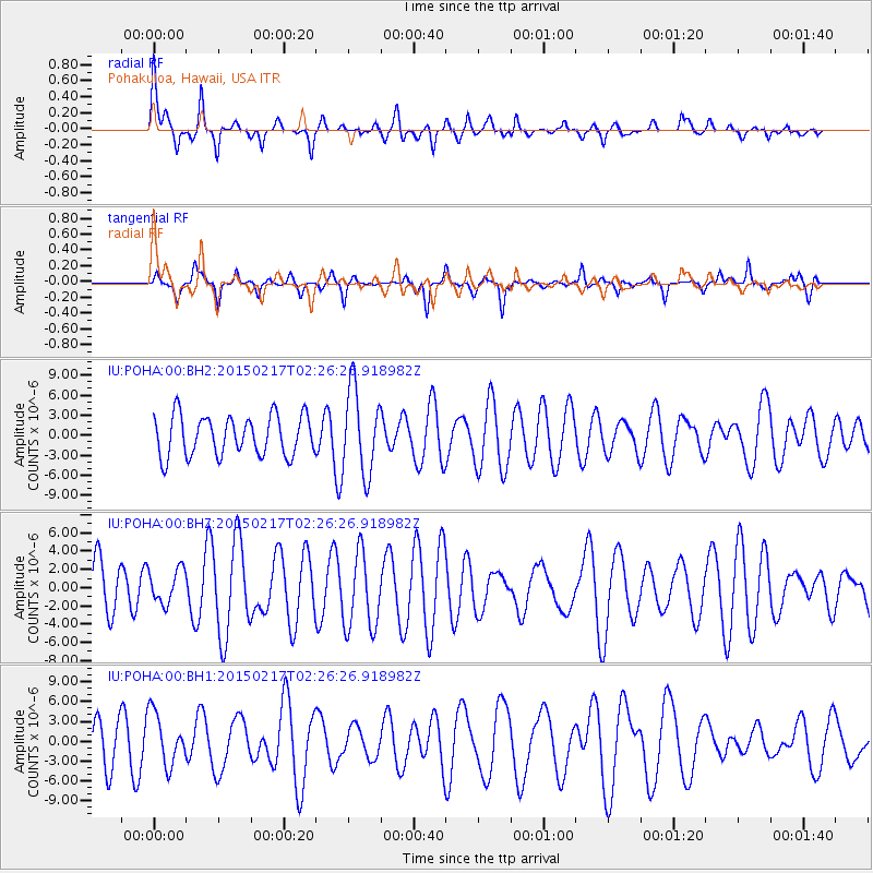
POHA Pohakuloa, Hawaii, USA - Earthquake Result Viewer
*The percent match for this event was below the threshold and hence no stack was calculated.
| Earthquake location: |
Northern Molucca Sea |
| Earthquake latitude/longitude: |
0.5/126.1 |
| Earthquake time(UTC): |
2015/02/17 (048) 02:14:59 GMT |
| Earthquake Depth: |
46 km |
| Earthquake Magnitude: |
5.5 MW |
| Earthquake Catalog/Contributor: |
ISC/ISC |
|
| Network: |
IU Global Seismograph Network (GSN - IRIS/USGS) |
| Station: |
POHA Pohakuloa, Hawaii, USA |
| Lat/Lon: |
19.76 N/155.53 W |
| Elevation: |
1990 m |
|
| Distance: |
78.9 deg |
| Az: |
70.078 deg |
| Baz: |
266.527 deg |
| Ray Param: |
$rayparam |
*The percent match for this event was below the threshold and hence was not used in the summary stack. |
|
| Radial Match: |
60.10166 % |
| Radial Bump: |
389 |
| Transverse Match: |
43.828358 % |
| Transverse Bump: |
254 |
| SOD ConfigId: |
7019011 |
| Insert Time: |
2019-04-16 21:05:12.824 +0000 |
| GWidth: |
2.5 |
| Max Bumps: |
400 |
| Tol: |
0.001 |
|
Signal To Noise
| Channel | StoN | STA | LTA |
| IU:POHA:00:BHZ:20150217T02:26:26.918982Z | 0.7397914 | 1.8743767E-6 | 2.533656E-6 |
| IU:POHA:00:BH1:20150217T02:26:26.918982Z | 1.1410716 | 3.947423E-6 | 3.4594E-6 |
| IU:POHA:00:BH2:20150217T02:26:26.918982Z | 2.1259706 | 6.372076E-6 | 2.9972548E-6 |
| Arrivals |
| Ps | |
| PpPs | |
| PsPs/PpSs | |


