You are here: Home > Network List > UU - University of Utah Regional Network Stations List
> Station CVRU Castle Valley Ranch, Emery, UT, USA old TA-Q16A > Earthquake Result Viewer
CVRU Castle Valley Ranch, Emery, UT, USA old TA-Q16A - Earthquake Result Viewer
| Earthquake location: |
Tonga Islands |
| Earthquake latitude/longitude: |
-20.7/-174.7 |
| Earthquake time(UTC): |
2014/04/26 (116) 06:02:16 GMT |
| Earthquake Depth: |
10 km |
| Earthquake Magnitude: |
6.5 MWP |
| Earthquake Catalog/Contributor: |
NEIC PDE/NEIC COMCAT |
|
| Network: |
UU University of Utah Regional Network |
| Station: |
CVRU Castle Valley Ranch, Emery, UT, USA old TA-Q16A |
| Lat/Lon: |
38.92 N/111.17 W |
| Elevation: |
1912 m |
|
| Distance: |
83.9 deg |
| Az: |
44.595 deg |
| Baz: |
237.406 deg |
| Ray Param: |
0.045839794 |
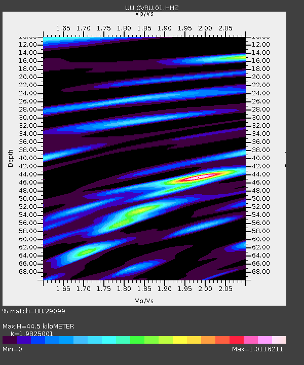
| Estimated Moho Depth: |
44.5 km |
| Estimated Crust Vp/Vs: |
1.98 |
| Assumed Crust Vp: |
6.207 km/s |
| Estimated Crust Vs: |
3.131 km/s |
| Estimated Crust Poisson's Ratio: |
0.33 |
|
| Radial Match: |
88.29099 % |
| Radial Bump: |
324 |
| Transverse Match: |
79.666954 % |
| Transverse Bump: |
365 |
| SOD ConfigId: |
626651 |
| Insert Time: |
2014-05-10 06:39:34.924 +0000 |
| GWidth: |
2.5 |
| Max Bumps: |
400 |
| Tol: |
0.001 |
|
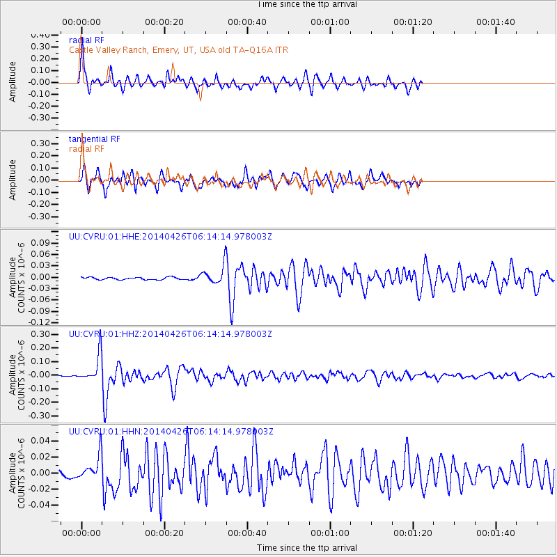
Signal To Noise
| Channel | StoN | STA | LTA |
| UU:CVRU:01:HHZ:20140426T06:14:14.978003Z | 26.559656 | 1.077397E-7 | 4.0565173E-9 |
| UU:CVRU:01:HHN:20140426T06:14:14.978003Z | 2.9348826 | 1.5391416E-8 | 5.244304E-9 |
| UU:CVRU:01:HHE:20140426T06:14:14.978003Z | 7.705852 | 2.3978314E-8 | 3.111702E-9 |
| Arrivals |
| Ps | 7.2 SECOND |
| PpPs | 21 SECOND |
| PsPs/PpSs | 28 SECOND |


