You are here: Home > Network List > UU - University of Utah Regional Network Stations List
> Station PKCU Pink Cliffs, UT, USA > Earthquake Result Viewer
PKCU Pink Cliffs, UT, USA - Earthquake Result Viewer
| Earthquake location: |
Tonga Islands |
| Earthquake latitude/longitude: |
-20.7/-174.7 |
| Earthquake time(UTC): |
2014/04/26 (116) 06:02:16 GMT |
| Earthquake Depth: |
10 km |
| Earthquake Magnitude: |
6.5 MWP |
| Earthquake Catalog/Contributor: |
NEIC PDE/NEIC COMCAT |
|
| Network: |
UU University of Utah Regional Network |
| Station: |
PKCU Pink Cliffs, UT, USA |
| Lat/Lon: |
37.44 N/112.31 W |
| Elevation: |
2834 m |
|
| Distance: |
82.4 deg |
| Az: |
45.348 deg |
| Baz: |
236.794 deg |
| Ray Param: |
0.046931718 |
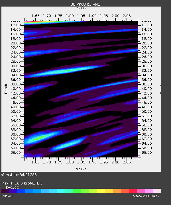
| Estimated Moho Depth: |
10.0 km |
| Estimated Crust Vp/Vs: |
1.62 |
| Assumed Crust Vp: |
6.194 km/s |
| Estimated Crust Vs: |
3.824 km/s |
| Estimated Crust Poisson's Ratio: |
0.19 |
|
| Radial Match: |
86.01286 % |
| Radial Bump: |
321 |
| Transverse Match: |
71.43883 % |
| Transverse Bump: |
400 |
| SOD ConfigId: |
626651 |
| Insert Time: |
2014-05-10 06:40:11.668 +0000 |
| GWidth: |
2.5 |
| Max Bumps: |
400 |
| Tol: |
0.001 |
|

Signal To Noise
| Channel | StoN | STA | LTA |
| UU:PKCU:01:HHZ:20140426T06:14:06.990027Z | 9.014573 | 5.039572E-8 | 5.590472E-9 |
| UU:PKCU:01:HHN:20140426T06:14:06.990027Z | 0.8093495 | 1.1667324E-8 | 1.4415681E-8 |
| UU:PKCU:01:HHE:20140426T06:14:06.990027Z | 1.7948394 | 2.4630587E-8 | 1.3723004E-8 |
| Arrivals |
| Ps | 1.0 SECOND |
| PpPs | 4.1 SECOND |
| PsPs/PpSs | 5.1 SECOND |


