You are here: Home > Network List > UU - University of Utah Regional Network Stations List
> Station ZNPU Zion National Park, UT, USA > Earthquake Result Viewer
ZNPU Zion National Park, UT, USA - Earthquake Result Viewer
| Earthquake location: |
Tonga Islands |
| Earthquake latitude/longitude: |
-20.7/-174.7 |
| Earthquake time(UTC): |
2014/04/26 (116) 06:02:16 GMT |
| Earthquake Depth: |
10 km |
| Earthquake Magnitude: |
6.5 MWP |
| Earthquake Catalog/Contributor: |
NEIC PDE/NEIC COMCAT |
|
| Network: |
UU University of Utah Regional Network |
| Station: |
ZNPU Zion National Park, UT, USA |
| Lat/Lon: |
37.36 N/113.13 W |
| Elevation: |
1953 m |
|
| Distance: |
81.8 deg |
| Az: |
45.061 deg |
| Baz: |
236.262 deg |
| Ray Param: |
0.047343105 |
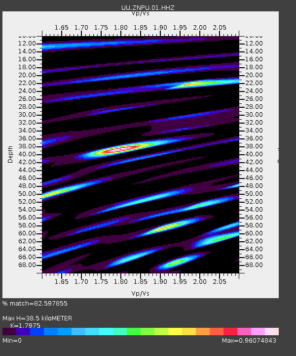
| Estimated Moho Depth: |
38.5 km |
| Estimated Crust Vp/Vs: |
1.80 |
| Assumed Crust Vp: |
6.194 km/s |
| Estimated Crust Vs: |
3.446 km/s |
| Estimated Crust Poisson's Ratio: |
0.28 |
|
| Radial Match: |
82.597855 % |
| Radial Bump: |
400 |
| Transverse Match: |
70.299614 % |
| Transverse Bump: |
400 |
| SOD ConfigId: |
626651 |
| Insert Time: |
2014-05-10 06:41:01.661 +0000 |
| GWidth: |
2.5 |
| Max Bumps: |
400 |
| Tol: |
0.001 |
|

Signal To Noise
| Channel | StoN | STA | LTA |
| UU:ZNPU:01:HHZ:20140426T06:14:03.897986Z | 22.904715 | 8.7355545E-8 | 3.8138674E-9 |
| UU:ZNPU:01:HHN:20140426T06:14:03.897986Z | 3.048247 | 1.5260252E-8 | 5.006238E-9 |
| UU:ZNPU:01:HHE:20140426T06:14:03.897986Z | 4.433323 | 2.3332884E-8 | 5.263069E-9 |
| Arrivals |
| Ps | 5.1 SECOND |
| PpPs | 17 SECOND |
| PsPs/PpSs | 22 SECOND |


