You are here: Home > Network List > II - Global Seismograph Network (GSN - IRIS/IDA) Stations List
> Station PFO Pinon Flat, California, USA > Earthquake Result Viewer
PFO Pinon Flat, California, USA - Earthquake Result Viewer

| Earthquake location: |
Near Coast Of Nicaragua |
| Earthquake latitude/longitude: |
11.3/-86.8 |
| Earthquake time(UTC): |
1992/09/02 (246) 18:28:56 GMT |
| Earthquake Depth: |
10 km |
| Earthquake Magnitude: |
5.2 MB, 5.8 MS |
| Earthquake Catalog/Contributor: |
WHDF/NEIC |
|
| Network: |
II Global Seismograph Network (GSN - IRIS/IDA) |
| Station: |
PFO Pinon Flat, California, USA |
| Lat/Lon: |
33.61 N/116.46 W |
| Elevation: |
1280 m |
|
| Distance: |
35.1 deg |
| Az: |
314.013 deg |
| Baz: |
122.292 deg |
| Ray Param: |
0.077398695 |
| Estimated Moho Depth: |
33.0 km |
| Estimated Crust Vp/Vs: |
1.61 |
| Assumed Crust Vp: |
6.264 km/s |
| Estimated Crust Vs: |
3.903 km/s |
| Estimated Crust Poisson's Ratio: |
0.18 |
|
| Radial Match: |
93.19867 % |
| Radial Bump: |
308 |
| Transverse Match: |
81.45581 % |
| Transverse Bump: |
400 |
| SOD ConfigId: |
17000 |
| Insert Time: |
2010-03-01 21:33:53.012 +0000 |
| GWidth: |
2.5 |
| Max Bumps: |
400 |
| Tol: |
0.001 |
|
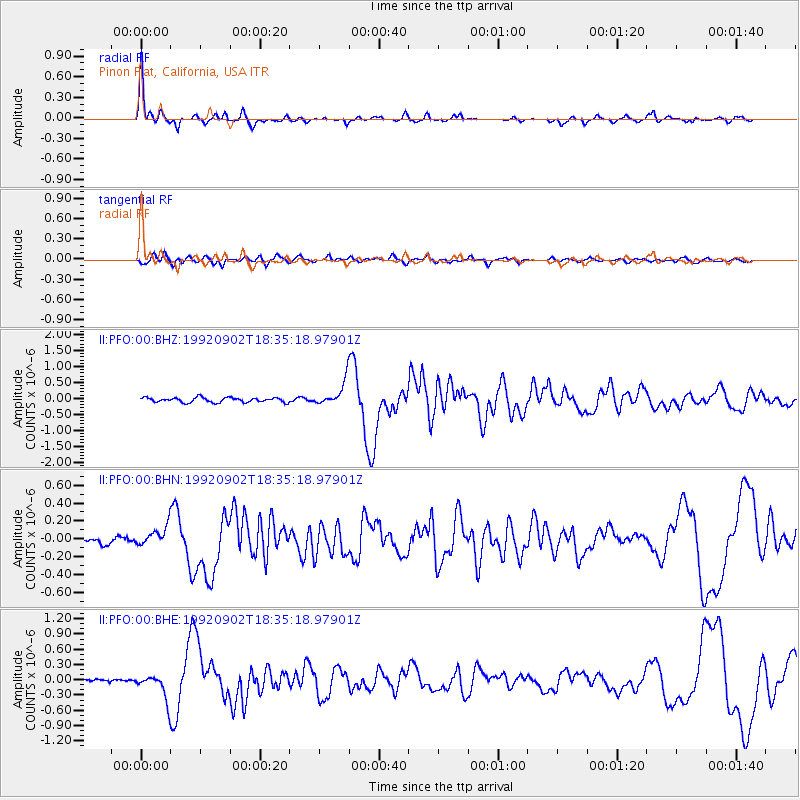
Signal To Noise
| Channel | StoN | STA | LTA |
| II:PFO:00:BHN:19920902T18:35:18.97901Z | 2.597471 | 1.05454795E-7 | 4.0599026E-8 |
| II:PFO:00:BHE:19920902T18:35:18.97901Z | 4.6000657 | 2.3733786E-7 | 5.159445E-8 |
| II:PFO:00:BHZ:19920902T18:35:18.97901Z | 5.1334615 | 3.752197E-7 | 7.309293E-8 |
| Arrivals |
| Ps | 3.5 SECOND |
| PpPs | 13 SECOND |
| PsPs/PpSs | 16 SECOND |


