You are here: Home > Network List > WY - Yellowstone Wyoming Seismic Network Stations List
> Station YHH Holmes Hill, YNP, WY, USA > Earthquake Result Viewer
YHH Holmes Hill, YNP, WY, USA - Earthquake Result Viewer
| Earthquake location: |
Tonga Islands |
| Earthquake latitude/longitude: |
-20.7/-174.7 |
| Earthquake time(UTC): |
2014/04/26 (116) 06:02:16 GMT |
| Earthquake Depth: |
10 km |
| Earthquake Magnitude: |
6.5 MWP |
| Earthquake Catalog/Contributor: |
NEIC PDE/NEIC COMCAT |
|
| Network: |
WY Yellowstone Wyoming Seismic Network |
| Station: |
YHH Holmes Hill, YNP, WY, USA |
| Lat/Lon: |
44.79 N/110.85 W |
| Elevation: |
2717 m |
|
| Distance: |
87.3 deg |
| Az: |
39.773 deg |
| Baz: |
237.25 deg |
| Ray Param: |
0.043423045 |
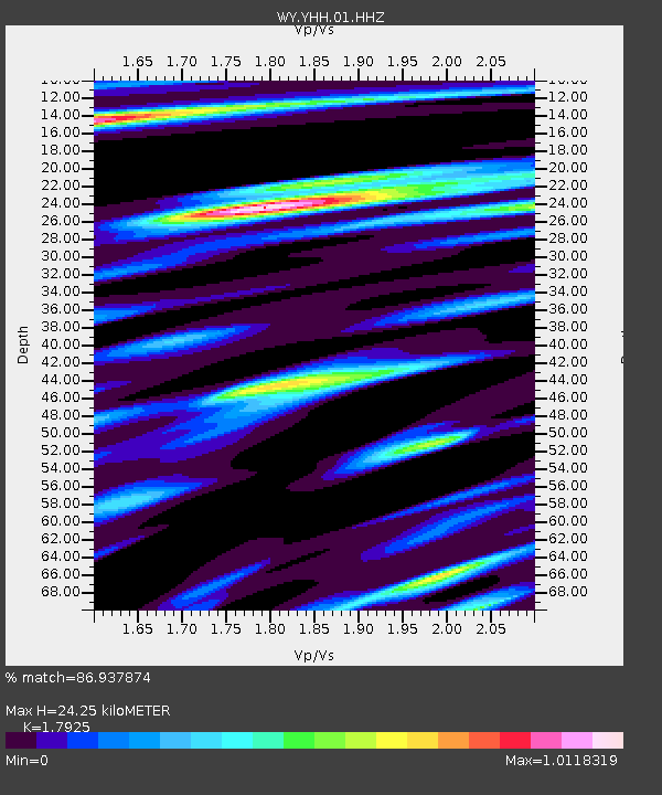
| Estimated Moho Depth: |
24.25 km |
| Estimated Crust Vp/Vs: |
1.79 |
| Assumed Crust Vp: |
6.35 km/s |
| Estimated Crust Vs: |
3.543 km/s |
| Estimated Crust Poisson's Ratio: |
0.27 |
|
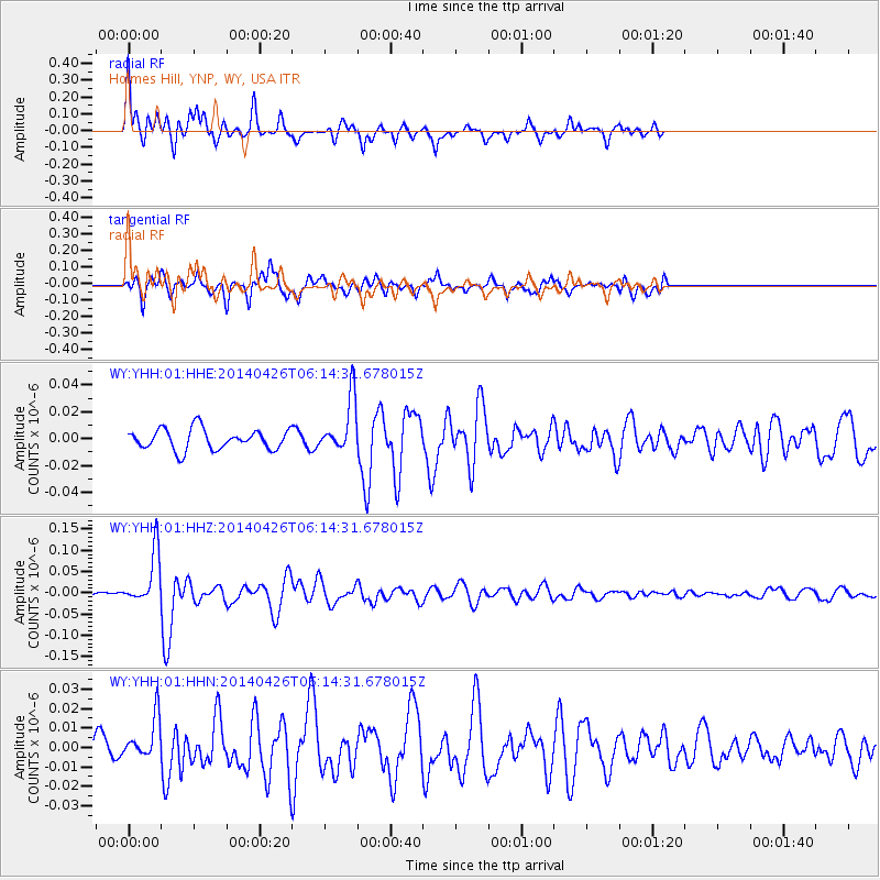
| Radial Match: |
86.937874 % |
| Radial Bump: |
400 |
| Transverse Match: |
88.95064 % |
| Transverse Bump: |
400 |
| SOD ConfigId: |
626651 |
| Insert Time: |
2014-05-10 06:43:25.906 +0000 |
| GWidth: |
2.5 |
| Max Bumps: |
400 |
| Tol: |
0.001 |
|
Signal To Noise
| Channel | StoN | STA | LTA |
| WY:YHH:01:HHZ:20140426T06:14:31.678015Z | 13.548035 | 6.250055E-8 | 4.613256E-9 |
| WY:YHH:01:HHN:20140426T06:14:31.678015Z | 2.1899354 | 1.0860612E-8 | 4.95933E-9 |
| WY:YHH:01:HHE:20140426T06:14:31.678015Z | 2.6369834 | 2.00896E-8 | 7.618402E-9 |
| Arrivals |
| Ps | 3.1 SECOND |
| PpPs | 10 SECOND |
| PsPs/PpSs | 14 SECOND |


