You are here: Home > Network List > II - Global Seismograph Network (GSN - IRIS/IDA) Stations List
> Station PFO Pinon Flat, California, USA > Earthquake Result Viewer
PFO Pinon Flat, California, USA - Earthquake Result Viewer

| Earthquake location: |
Vanuatu Islands |
| Earthquake latitude/longitude: |
-19.3/168.9 |
| Earthquake time(UTC): |
1992/10/11 (285) 19:24:29 GMT |
| Earthquake Depth: |
157 km |
| Earthquake Magnitude: |
6.4 MB |
| Earthquake Catalog/Contributor: |
WHDF/NEIC |
|
| Network: |
II Global Seismograph Network (GSN - IRIS/IDA) |
| Station: |
PFO Pinon Flat, California, USA |
| Lat/Lon: |
33.61 N/116.46 W |
| Elevation: |
1280 m |
|
| Distance: |
88.4 deg |
| Az: |
53.612 deg |
| Baz: |
245.673 deg |
| Ray Param: |
0.042271238 |
| Estimated Moho Depth: |
29.75 km |
| Estimated Crust Vp/Vs: |
1.62 |
| Assumed Crust Vp: |
6.264 km/s |
| Estimated Crust Vs: |
3.855 km/s |
| Estimated Crust Poisson's Ratio: |
0.20 |
|
| Radial Match: |
96.407166 % |
| Radial Bump: |
400 |
| Transverse Match: |
89.717255 % |
| Transverse Bump: |
400 |
| SOD ConfigId: |
61242 |
| Insert Time: |
2010-03-01 21:33:58.576 +0000 |
| GWidth: |
2.5 |
| Max Bumps: |
400 |
| Tol: |
0.001 |
|
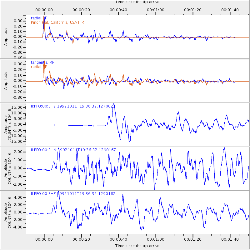
Signal To Noise
| Channel | StoN | STA | LTA |
| II:PFO:00:BHN:19921011T19:36:32.129016Z | 2.236226 | 2.1057663E-7 | 9.4166076E-8 |
| II:PFO:00:BHE:19921011T19:36:32.129016Z | 3.8245707 | 4.3478332E-7 | 1.13681594E-7 |
| II:PFO:00:BHZ:19921011T19:36:32.127002Z | 10.030041 | 1.9867302E-6 | 1.9807798E-7 |
| Arrivals |
| Ps | 3.0 SECOND |
| PpPs | 12 SECOND |
| PsPs/PpSs | 15 SECOND |


