You are here: Home > Network List > PF - Volcanologic Network of Piton de Fournaise-OVPF Stations List
> Station HIM cratere Himiltrude > Earthquake Result Viewer
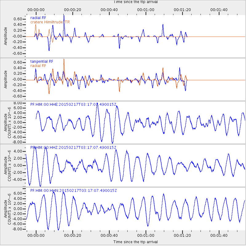
HIM cratere Himiltrude - Earthquake Result Viewer
*The percent match for this event was below the threshold and hence no stack was calculated.
| Earthquake location: |
South Sandwich Islands Region |
| Earthquake latitude/longitude: |
-55.5/-28.2 |
| Earthquake time(UTC): |
2015/02/17 (048) 03:06:33 GMT |
| Earthquake Depth: |
26 km |
| Earthquake Magnitude: |
5.4 MW |
| Earthquake Catalog/Contributor: |
ISC/ISC |
|
| Network: |
PF Volcanologic Network of Piton de Fournaise-OVPF |
| Station: |
HIM cratere Himiltrude |
| Lat/Lon: |
21.21 S/55.72 E |
| Elevation: |
1958 m |
|
| Distance: |
69.4 deg |
| Az: |
97.58 deg |
| Baz: |
217.236 deg |
| Ray Param: |
$rayparam |
*The percent match for this event was below the threshold and hence was not used in the summary stack. |
|
| Radial Match: |
86.30432 % |
| Radial Bump: |
302 |
| Transverse Match: |
53.419765 % |
| Transverse Bump: |
400 |
| SOD ConfigId: |
7019011 |
| Insert Time: |
2019-04-16 21:10:03.074 +0000 |
| GWidth: |
2.5 |
| Max Bumps: |
400 |
| Tol: |
0.001 |
|
Signal To Noise
| Channel | StoN | STA | LTA |
| PF:HIM:00:HHZ:20150217T03:17:07.490015Z | 1.2808951 | 3.905131E-6 | 3.0487515E-6 |
| PF:HIM:00:HHN:20150217T03:17:07.490015Z | 1.9676945 | 3.6631002E-6 | 1.8616204E-6 |
| PF:HIM:00:HHE:20150217T03:17:07.490015Z | 2.0300648 | 4.2708566E-6 | 2.103803E-6 |
| Arrivals |
| Ps | |
| PpPs | |
| PsPs/PpSs | |


