You are here: Home > Network List > CI - Caltech Regional Seismic Network Stations List
> Station BAR Barrett, Tecate, CA, USA > Earthquake Result Viewer
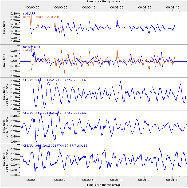
BAR Barrett, Tecate, CA, USA - Earthquake Result Viewer
*The percent match for this event was below the threshold and hence no stack was calculated.
| Earthquake location: |
Near East Coast Of Honshu, Japan |
| Earthquake latitude/longitude: |
40.2/141.9 |
| Earthquake time(UTC): |
2015/02/17 (048) 04:46:38 GMT |
| Earthquake Depth: |
40 km |
| Earthquake Magnitude: |
5.8 MB |
| Earthquake Catalog/Contributor: |
NEIC PDE/NEIC COMCAT |
|
| Network: |
CI Caltech Regional Seismic Network |
| Station: |
BAR Barrett, Tecate, CA, USA |
| Lat/Lon: |
32.68 N/116.67 W |
| Elevation: |
521 m |
|
| Distance: |
77.5 deg |
| Az: |
57.867 deg |
| Baz: |
309.707 deg |
| Ray Param: |
$rayparam |
*The percent match for this event was below the threshold and hence was not used in the summary stack. |
|
| Radial Match: |
71.11679 % |
| Radial Bump: |
400 |
| Transverse Match: |
41.631233 % |
| Transverse Bump: |
400 |
| SOD ConfigId: |
7019011 |
| Insert Time: |
2019-04-16 21:13:47.261 +0000 |
| GWidth: |
2.5 |
| Max Bumps: |
400 |
| Tol: |
0.001 |
|
Signal To Noise
| Channel | StoN | STA | LTA |
| CI:BAR: :HHZ:20150217T04:57:57.718013Z | 2.185473 | 3.3456706E-7 | 1.5308682E-7 |
| CI:BAR: :HHN:20150217T04:57:57.718013Z | 1.3025793 | 1.5201464E-7 | 1.1670279E-7 |
| CI:BAR: :HHE:20150217T04:57:57.718013Z | 0.45286322 | 8.873635E-8 | 1.9594516E-7 |
| Arrivals |
| Ps | |
| PpPs | |
| PsPs/PpSs | |


