You are here: Home > Network List > IU - Global Seismograph Network (GSN - IRIS/USGS) Stations List
> Station CTAO Charters Towers, Australia > Earthquake Result Viewer
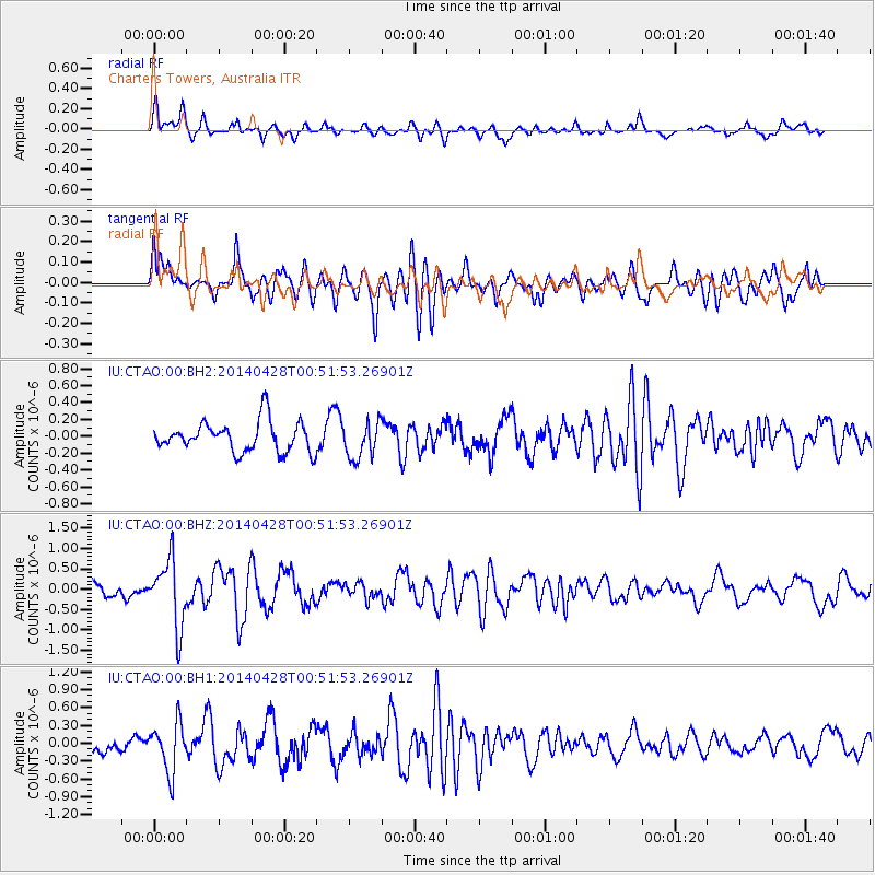
CTAO Charters Towers, Australia - Earthquake Result Viewer
*The percent match for this event was below the threshold and hence no stack was calculated.
| Earthquake location: |
Philippine Islands Region |
| Earthquake latitude/longitude: |
19.7/120.0 |
| Earthquake time(UTC): |
2014/04/28 (118) 00:43:51 GMT |
| Earthquake Depth: |
10 km |
| Earthquake Magnitude: |
5.6 MWP |
| Earthquake Catalog/Contributor: |
NEIC PDE/NEIC COMCAT |
|
| Network: |
IU Global Seismograph Network (GSN - IRIS/USGS) |
| Station: |
CTAO Charters Towers, Australia |
| Lat/Lon: |
20.09 S/146.25 E |
| Elevation: |
357 m |
|
| Distance: |
47.2 deg |
| Az: |
145.512 deg |
| Baz: |
325.42 deg |
| Ray Param: |
$rayparam |
*The percent match for this event was below the threshold and hence was not used in the summary stack. |
|
| Radial Match: |
61.702454 % |
| Radial Bump: |
400 |
| Transverse Match: |
75.905304 % |
| Transverse Bump: |
400 |
| SOD ConfigId: |
626651 |
| Insert Time: |
2014-05-12 01:12:38.838 +0000 |
| GWidth: |
2.5 |
| Max Bumps: |
400 |
| Tol: |
0.001 |
|
Signal To Noise
| Channel | StoN | STA | LTA |
| IU:CTAO:00:BHZ:20140428T00:51:53.26901Z | 3.191778 | 8.1860514E-7 | 2.5647307E-7 |
| IU:CTAO:00:BH1:20140428T00:51:53.26901Z | 3.1001825 | 4.1270965E-7 | 1.331243E-7 |
| IU:CTAO:00:BH2:20140428T00:51:53.26901Z | 1.2342521 | 2.1733103E-7 | 1.7608319E-7 |
| Arrivals |
| Ps | |
| PpPs | |
| PsPs/PpSs | |


