PFO Pinon Flat, California, USA - Earthquake Result Viewer
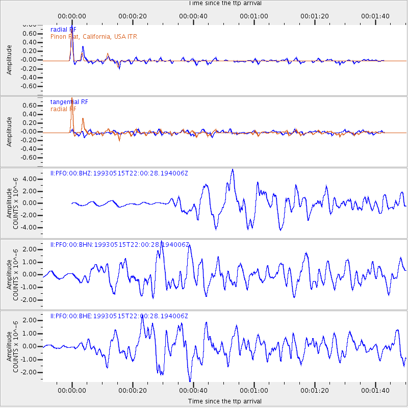
Earthquake location: Andreanof Islands, Aleutian Is.
Earthquake latitude/longitude: 51.3/-178.7
Earthquake time(UTC): 1993/05/15 (135) 21:52:25 GMT
Earthquake Depth: 33 km
Earthquake Magnitude: 6.2 MB, 6.5 MS, 6.3 UNKNOWN, 6.1 ML
Earthquake Catalog/Contributor: WHDF/NEIC
Network: II Global Seismograph Network (GSN - IRIS/IDA)
Station: PFO Pinon Flat, California, USA
Lat/Lon: 33.61 N/116.46 W
Elevation: 1280 m
Distance: 47.7 deg
Az: 86.705 deg
Baz: 311.377 deg
Ray Param: 0.06976888
Estimated Moho Depth: 29.0 km
Estimated Crust Vp/Vs: 1.75
Assumed Crust Vp: 6.264 km/s
Estimated Crust Vs: 3.574 km/s
Estimated Crust Poisson's Ratio: 0.26
Radial Match: 94.903946 %
Radial Bump: 321
Transverse Match: 79.19752 %
Transverse Bump: 400
SOD ConfigId: 61242
Insert Time: 2010-03-01 21:34:35.553 +0000
GWidth: 2.5
Max Bumps: 400
Tol: 0.001

Signal To Noise

ChannelStoNSTALTA
II:PFO:00:BHN:19930515T22:00:28.194006Z1.44251182.819798E-71.9547832E-7
II:PFO:00:BHE:19930515T22:00:28.194006Z0.51730591.5005988E-72.9007956E-7
II:PFO:00:BHZ:19930515T22:00:28.194006Z1.43582363.7815465E-72.6337125E-7
Arrivals
Ps3.7 SECOND
PpPs12 SECOND
PsPs/PpSs16 SECOND