You are here: Home > Network List > II - Global Seismograph Network (GSN - IRIS/IDA) Stations List
> Station PFO Pinon Flat, California, USA > Earthquake Result Viewer
PFO Pinon Flat, California, USA - Earthquake Result Viewer

| Earthquake location: |
Mariana Islands |
| Earthquake latitude/longitude: |
15.7/146.6 |
| Earthquake time(UTC): |
1993/06/06 (157) 13:23:27 GMT |
| Earthquake Depth: |
68 km |
| Earthquake Magnitude: |
5.8 MB, 6.4 UNKNOWN |
| Earthquake Catalog/Contributor: |
WHDF/NEIC |
|
| Network: |
II Global Seismograph Network (GSN - IRIS/IDA) |
| Station: |
PFO Pinon Flat, California, USA |
| Lat/Lon: |
33.61 N/116.46 W |
| Elevation: |
1280 m |
|
| Distance: |
87.1 deg |
| Az: |
56.04 deg |
| Baz: |
286.792 deg |
| Ray Param: |
0.04343267 |
| Estimated Moho Depth: |
20.0 km |
| Estimated Crust Vp/Vs: |
1.86 |
| Assumed Crust Vp: |
6.264 km/s |
| Estimated Crust Vs: |
3.363 km/s |
| Estimated Crust Poisson's Ratio: |
0.30 |
|
| Radial Match: |
95.11038 % |
| Radial Bump: |
400 |
| Transverse Match: |
86.83648 % |
| Transverse Bump: |
400 |
| SOD ConfigId: |
61242 |
| Insert Time: |
2010-03-01 21:34:41.712 +0000 |
| GWidth: |
2.5 |
| Max Bumps: |
400 |
| Tol: |
0.001 |
|
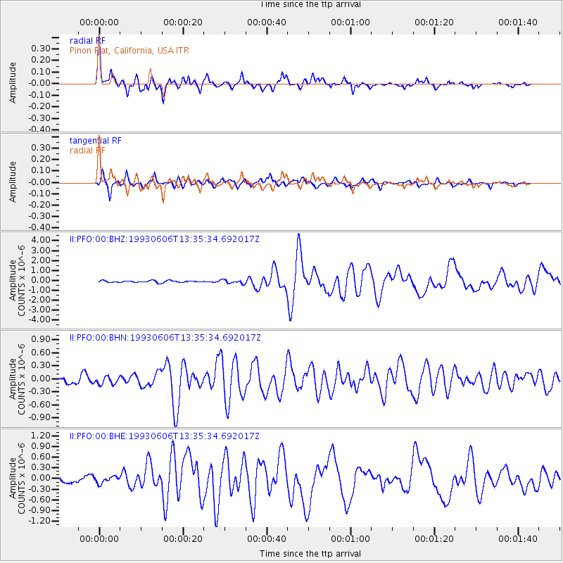
Signal To Noise
| Channel | StoN | STA | LTA |
| II:PFO:00:BHN:19930606T13:35:34.692017Z | 1.2566419 | 8.6050825E-8 | 6.847681E-8 |
| II:PFO:00:BHE:19930606T13:35:34.692017Z | 1.124241 | 1.00883405E-7 | 8.9734684E-8 |
| II:PFO:00:BHZ:19930606T13:35:34.692017Z | 1.8614697 | 1.7439582E-7 | 9.368716E-8 |
| Arrivals |
| Ps | 2.8 SECOND |
| PpPs | 9.0 SECOND |
| PsPs/PpSs | 12 SECOND |


