You are here: Home > Network List > II - Global Seismograph Network (GSN - IRIS/IDA) Stations List
> Station PFO Pinon Flat, California, USA > Earthquake Result Viewer
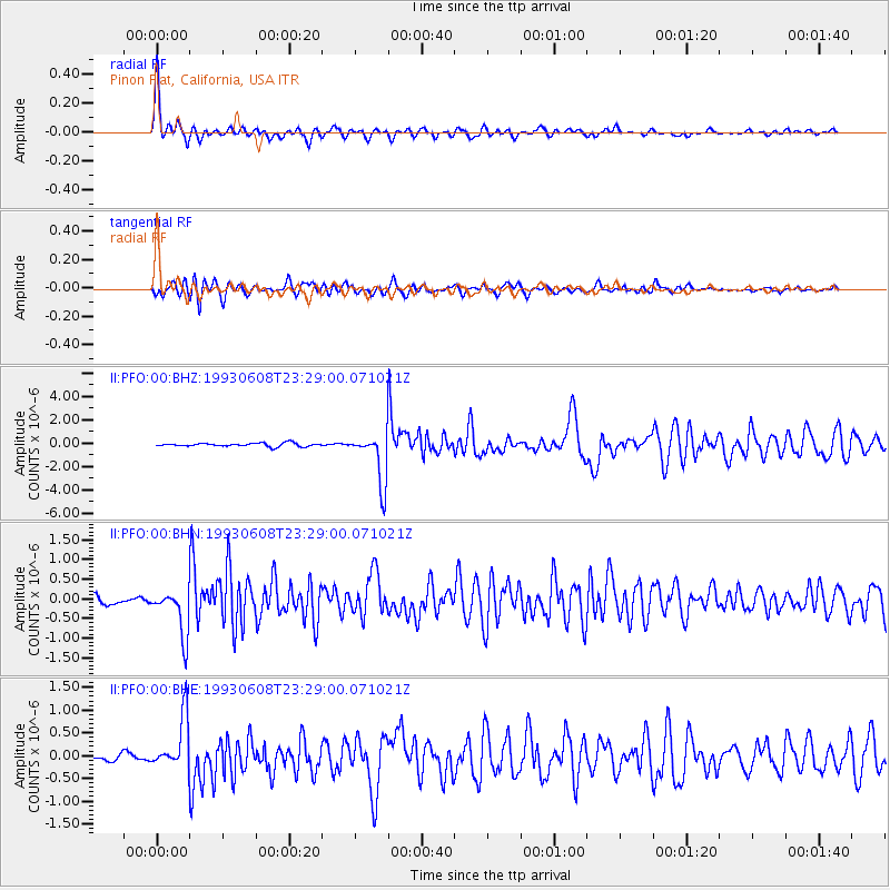
PFO Pinon Flat, California, USA - Earthquake Result Viewer

| Earthquake location: |
San Juan Province, Argentina |
| Earthquake latitude/longitude: |
-31.6/-69.2 |
| Earthquake time(UTC): |
1993/06/08 (159) 23:17:41 GMT |
| Earthquake Depth: |
113 km |
| Earthquake Magnitude: |
6.4 MB, 6.4 UNKNOWN |
| Earthquake Catalog/Contributor: |
WHDF/NEIC |
|
| Network: |
II Global Seismograph Network (GSN - IRIS/IDA) |
| Station: |
PFO Pinon Flat, California, USA |
| Lat/Lon: |
33.61 N/116.46 W |
| Elevation: |
1280 m |
|
| Distance: |
78.7 deg |
| Az: |
321.331 deg |
| Baz: |
140.291 deg |
| Ray Param: |
0.049218785 |
| Estimated Moho Depth: |
59.0 km |
| Estimated Crust Vp/Vs: |
1.91 |
| Assumed Crust Vp: |
6.264 km/s |
| Estimated Crust Vs: |
3.279 km/s |
| Estimated Crust Poisson's Ratio: |
0.31 |
|
| Radial Match: |
94.64879 % |
| Radial Bump: |
341 |
| Transverse Match: |
86.11522 % |
| Transverse Bump: |
400 |
| SOD ConfigId: |
17000 |
| Insert Time: |
2010-03-01 21:34:50.528 +0000 |
| GWidth: |
2.5 |
| Max Bumps: |
400 |
| Tol: |
0.001 |
|
Signal To Noise
| Channel | StoN | STA | LTA |
| II:PFO:00:BHN:19930608T23:29:00.071021Z | 4.751206 | 5.9279637E-7 | 1.2476757E-7 |
| II:PFO:00:BHE:19930608T23:29:00.071021Z | 6.3502393 | 5.80608E-7 | 9.143089E-8 |
| II:PFO:00:BHZ:19930608T23:29:00.071021Z | 14.991041 | 2.1921496E-6 | 1.4623065E-7 |
| Arrivals |
| Ps | 8.8 SECOND |
| PpPs | 27 SECOND |
| PsPs/PpSs | 36 SECOND |


