You are here: Home > Network List > TA - USArray Transportable Network (new EarthScope stations) Stations List
> Station KSCO Kaye Shedlock's, Cheyenne Wells, CO, USA > Earthquake Result Viewer
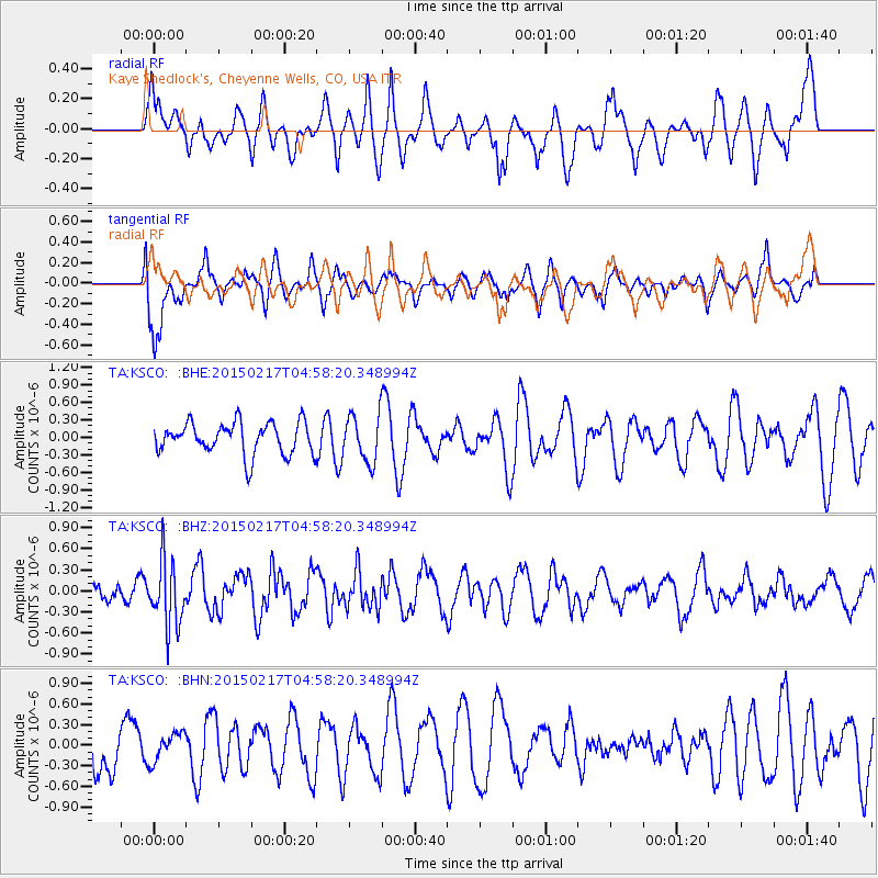
KSCO Kaye Shedlock's, Cheyenne Wells, CO, USA - Earthquake Result Viewer
*The percent match for this event was below the threshold and hence no stack was calculated.
| Earthquake location: |
Near East Coast Of Honshu, Japan |
| Earthquake latitude/longitude: |
40.2/141.9 |
| Earthquake time(UTC): |
2015/02/17 (048) 04:46:38 GMT |
| Earthquake Depth: |
40 km |
| Earthquake Magnitude: |
5.8 MB |
| Earthquake Catalog/Contributor: |
NEIC PDE/NEIC COMCAT |
|
| Network: |
TA USArray Transportable Network (new EarthScope stations) |
| Station: |
KSCO Kaye Shedlock's, Cheyenne Wells, CO, USA |
| Lat/Lon: |
39.01 N/102.63 W |
| Elevation: |
1382 m |
|
| Distance: |
81.6 deg |
| Az: |
45.31 deg |
| Baz: |
315.642 deg |
| Ray Param: |
$rayparam |
*The percent match for this event was below the threshold and hence was not used in the summary stack. |
|
| Radial Match: |
56.250572 % |
| Radial Bump: |
400 |
| Transverse Match: |
51.408173 % |
| Transverse Bump: |
358 |
| SOD ConfigId: |
7019011 |
| Insert Time: |
2019-04-16 21:20:24.527 +0000 |
| GWidth: |
2.5 |
| Max Bumps: |
400 |
| Tol: |
0.001 |
|
Signal To Noise
| Channel | StoN | STA | LTA |
| TA:KSCO: :BHZ:20150217T04:58:20.348994Z | 4.742234 | 4.6614582E-7 | 9.829667E-8 |
| TA:KSCO: :BHN:20150217T04:58:20.348994Z | 0.40900487 | 2.0983892E-7 | 5.1304744E-7 |
| TA:KSCO: :BHE:20150217T04:58:20.348994Z | 1.9355009 | 5.295446E-7 | 2.7359562E-7 |
| Arrivals |
| Ps | |
| PpPs | |
| PsPs/PpSs | |


