You are here: Home > Network List > TA - USArray Transportable Network (new EarthScope stations) Stations List
> Station P56A Dayton Farm, Ripley, WV, USA > Earthquake Result Viewer
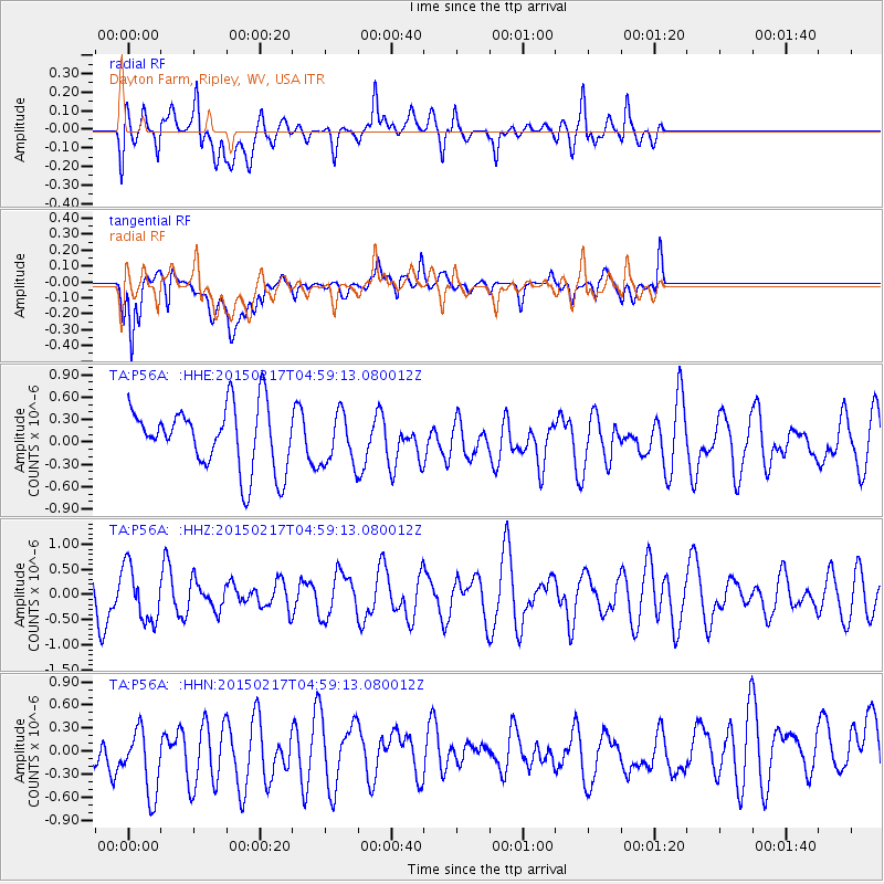
P56A Dayton Farm, Ripley, WV, USA - Earthquake Result Viewer
*The percent match for this event was below the threshold and hence no stack was calculated.
| Earthquake location: |
Near East Coast Of Honshu, Japan |
| Earthquake latitude/longitude: |
40.2/141.9 |
| Earthquake time(UTC): |
2015/02/17 (048) 04:46:38 GMT |
| Earthquake Depth: |
40 km |
| Earthquake Magnitude: |
5.8 MB |
| Earthquake Catalog/Contributor: |
NEIC PDE/NEIC COMCAT |
|
| Network: |
TA USArray Transportable Network (new EarthScope stations) |
| Station: |
P56A Dayton Farm, Ripley, WV, USA |
| Lat/Lon: |
39.50 N/78.84 W |
| Elevation: |
249 m |
|
| Distance: |
92.4 deg |
| Az: |
30.348 deg |
| Baz: |
329.976 deg |
| Ray Param: |
$rayparam |
*The percent match for this event was below the threshold and hence was not used in the summary stack. |
|
| Radial Match: |
55.39192 % |
| Radial Bump: |
400 |
| Transverse Match: |
57.028522 % |
| Transverse Bump: |
400 |
| SOD ConfigId: |
7019011 |
| Insert Time: |
2019-04-16 21:20:38.035 +0000 |
| GWidth: |
2.5 |
| Max Bumps: |
400 |
| Tol: |
0.001 |
|
Signal To Noise
| Channel | StoN | STA | LTA |
| TA:P56A: :HHZ:20150217T04:59:13.080012Z | 1.067087 | 5.413974E-7 | 5.0736014E-7 |
| TA:P56A: :HHN:20150217T04:59:13.080012Z | 1.2891937 | 5.0848087E-7 | 3.944177E-7 |
| TA:P56A: :HHE:20150217T04:59:13.080012Z | 0.88064426 | 3.7026487E-7 | 4.2044772E-7 |
| Arrivals |
| Ps | |
| PpPs | |
| PsPs/PpSs | |


