You are here: Home > Network List > AU - Australian Seismological Centre Stations List
> Station PSAA2 Pilbara Seismic Array Element A2 > Earthquake Result Viewer
PSAA2 Pilbara Seismic Array Element A2 - Earthquake Result Viewer
| Earthquake location: |
Southeast Of Loyalty Islands |
| Earthquake latitude/longitude: |
-21.5/170.2 |
| Earthquake time(UTC): |
2014/05/01 (121) 06:36:37 GMT |
| Earthquake Depth: |
118 km |
| Earthquake Magnitude: |
6.7 MWP, 6.7 MI |
| Earthquake Catalog/Contributor: |
NEIC PDE/NEIC COMCAT |
|
| Network: |
AU Australian Seismological Centre |
| Station: |
PSAA2 Pilbara Seismic Array Element A2 |
| Lat/Lon: |
21.56 S/119.85 E |
| Elevation: |
330 m |
|
| Distance: |
46.7 deg |
| Az: |
260.201 deg |
| Baz: |
99.677 deg |
| Ray Param: |
0.070073836 |
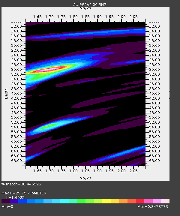
| Estimated Moho Depth: |
29.75 km |
| Estimated Crust Vp/Vs: |
1.69 |
| Assumed Crust Vp: |
6.464 km/s |
| Estimated Crust Vs: |
3.819 km/s |
| Estimated Crust Poisson's Ratio: |
0.23 |
|
| Radial Match: |
88.445595 % |
| Radial Bump: |
292 |
| Transverse Match: |
61.179916 % |
| Transverse Bump: |
400 |
| SOD ConfigId: |
626651 |
| Insert Time: |
2014-05-15 06:58:52.982 +0000 |
| GWidth: |
2.5 |
| Max Bumps: |
400 |
| Tol: |
0.001 |
|

Signal To Noise
| Channel | StoN | STA | LTA |
| AU:PSAA2:00:BHZ:20140501T06:44:24.294014Z | 17.162552 | 6.2217123E-6 | 3.6251672E-7 |
| AU:PSAA2:00:BH1:20140501T06:44:24.294014Z | 13.532176 | 3.6153074E-6 | 2.6716378E-7 |
| AU:PSAA2:00:BH2:20140501T06:44:24.294014Z | 1.4844139 | 4.1813848E-7 | 2.816859E-7 |
| Arrivals |
| Ps | 3.4 SECOND |
| PpPs | 12 SECOND |
| PsPs/PpSs | 15 SECOND |


