You are here: Home > Network List > G - GEOSCOPE Stations List
> Station INU Inuyama, Japan > Earthquake Result Viewer
INU Inuyama, Japan - Earthquake Result Viewer
| Earthquake location: |
Southeast Of Loyalty Islands |
| Earthquake latitude/longitude: |
-21.5/170.2 |
| Earthquake time(UTC): |
2014/05/01 (121) 06:36:37 GMT |
| Earthquake Depth: |
118 km |
| Earthquake Magnitude: |
6.7 MWP, 6.7 MI |
| Earthquake Catalog/Contributor: |
NEIC PDE/NEIC COMCAT |
|
| Network: |
G GEOSCOPE |
| Station: |
INU Inuyama, Japan |
| Lat/Lon: |
35.35 N/137.03 E |
| Elevation: |
132 m |
|
| Distance: |
64.7 deg |
| Az: |
330.339 deg |
| Baz: |
145.687 deg |
| Ray Param: |
0.058420468 |
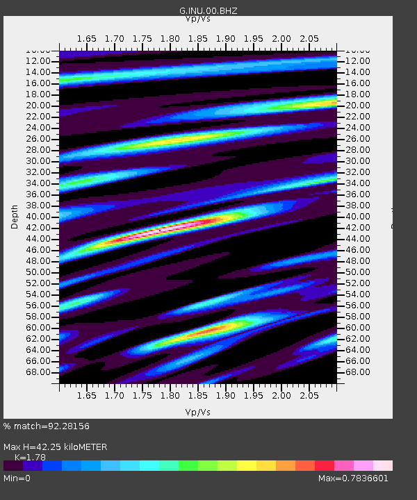
| Estimated Moho Depth: |
42.25 km |
| Estimated Crust Vp/Vs: |
1.78 |
| Assumed Crust Vp: |
6.461 km/s |
| Estimated Crust Vs: |
3.63 km/s |
| Estimated Crust Poisson's Ratio: |
0.27 |
|
| Radial Match: |
92.28156 % |
| Radial Bump: |
284 |
| Transverse Match: |
82.72581 % |
| Transverse Bump: |
325 |
| SOD ConfigId: |
626651 |
| Insert Time: |
2014-05-15 07:04:58.344 +0000 |
| GWidth: |
2.5 |
| Max Bumps: |
400 |
| Tol: |
0.001 |
|
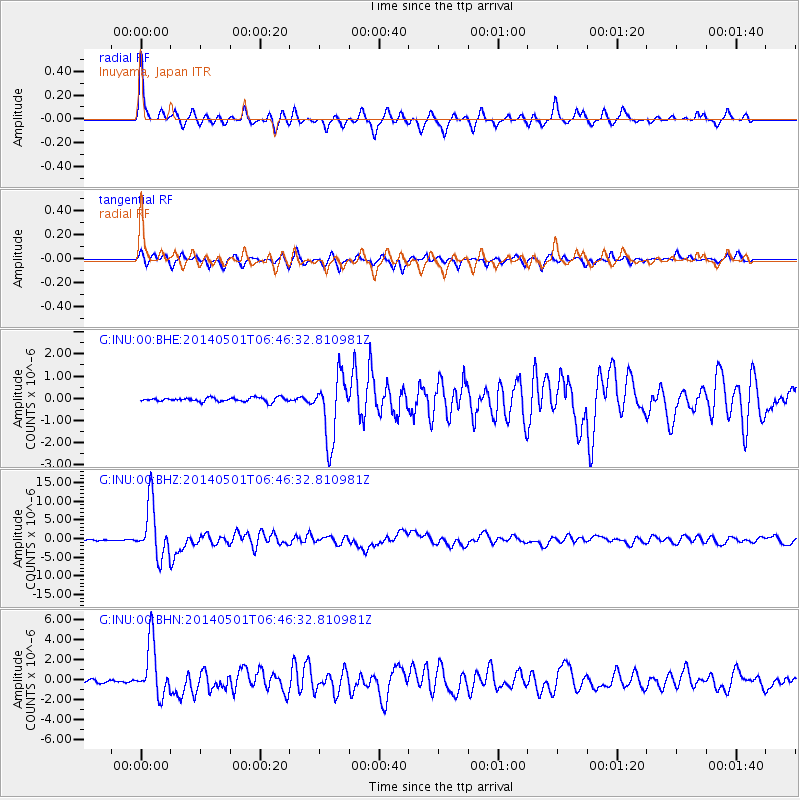
Signal To Noise
| Channel | StoN | STA | LTA |
| G:INU:00:BHZ:20140501T06:46:32.810981Z | 38.847878 | 7.2325524E-6 | 1.8617625E-7 |
| G:INU:00:BHN:20140501T06:46:32.810981Z | 14.6862955 | 2.6861435E-6 | 1.8290137E-7 |
| G:INU:00:BHE:20140501T06:46:32.810981Z | 15.65297 | 1.4219236E-6 | 9.0840494E-8 |
| Arrivals |
| Ps | 5.3 SECOND |
| PpPs | 17 SECOND |
| PsPs/PpSs | 23 SECOND |


