You are here: Home > Network List > IN - National Seismic Network of India Stations List
> Station SHL Shillong, Meghalaya, India > Earthquake Result Viewer
SHL Shillong, Meghalaya, India - Earthquake Result Viewer
| Earthquake location: |
Southeast Of Loyalty Islands |
| Earthquake latitude/longitude: |
-21.5/170.2 |
| Earthquake time(UTC): |
2014/05/01 (121) 06:36:37 GMT |
| Earthquake Depth: |
118 km |
| Earthquake Magnitude: |
6.7 MWP, 6.7 MI |
| Earthquake Catalog/Contributor: |
NEIC PDE/NEIC COMCAT |
|
| Network: |
IN National Seismic Network of India |
| Station: |
SHL Shillong, Meghalaya, India |
| Lat/Lon: |
25.57 N/91.86 E |
| Elevation: |
2.0 m |
|
| Distance: |
89.2 deg |
| Az: |
297.784 deg |
| Baz: |
114.199 deg |
| Ray Param: |
0.041750647 |
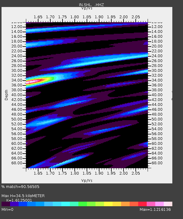
| Estimated Moho Depth: |
34.5 km |
| Estimated Crust Vp/Vs: |
1.61 |
| Assumed Crust Vp: |
6.273 km/s |
| Estimated Crust Vs: |
3.89 km/s |
| Estimated Crust Poisson's Ratio: |
0.19 |
|
| Radial Match: |
90.56585 % |
| Radial Bump: |
400 |
| Transverse Match: |
75.75524 % |
| Transverse Bump: |
400 |
| SOD ConfigId: |
626651 |
| Insert Time: |
2014-05-15 07:07:17.852 +0000 |
| GWidth: |
2.5 |
| Max Bumps: |
400 |
| Tol: |
0.001 |
|

Signal To Noise
| Channel | StoN | STA | LTA |
| IN:SHL: :HHZ:20140501T06:48:49.45002Z | 59.731087 | 4.375144E-6 | 7.324735E-8 |
| IN:SHL: :HHN:20140501T06:48:49.45002Z | 2.686324 | 4.6575224E-7 | 1.7337904E-7 |
| IN:SHL: :HHE:20140501T06:48:49.45002Z | 19.639238 | 1.4843934E-6 | 7.558304E-8 |
| Arrivals |
| Ps | 3.4 SECOND |
| PpPs | 14 SECOND |
| PsPs/PpSs | 18 SECOND |


