You are here: Home > Network List > IU - Global Seismograph Network (GSN - IRIS/USGS) Stations List
> Station JOHN Johnston Island, USA > Earthquake Result Viewer
JOHN Johnston Island, USA - Earthquake Result Viewer
*The percent match for this event was below the threshold and hence no stack was calculated.
| Earthquake location: |
Southeast Of Loyalty Islands |
| Earthquake latitude/longitude: |
-21.5/170.2 |
| Earthquake time(UTC): |
2014/05/01 (121) 06:36:37 GMT |
| Earthquake Depth: |
118 km |
| Earthquake Magnitude: |
6.7 MWP, 6.7 MI |
| Earthquake Catalog/Contributor: |
NEIC PDE/NEIC COMCAT |
|
| Network: |
IU Global Seismograph Network (GSN - IRIS/USGS) |
| Station: |
JOHN Johnston Island, USA |
| Lat/Lon: |
16.73 N/169.53 W |
| Elevation: |
2.0 m |
|
| Distance: |
42.9 deg |
| Az: |
29.175 deg |
| Baz: |
208.278 deg |
| Ray Param: |
$rayparam |
*The percent match for this event was below the threshold and hence was not used in the summary stack. |
|
| Radial Match: |
67.606575 % |
| Radial Bump: |
400 |
| Transverse Match: |
56.504086 % |
| Transverse Bump: |
400 |
| SOD ConfigId: |
626651 |
| Insert Time: |
2014-05-15 07:07:50.677 +0000 |
| GWidth: |
2.5 |
| Max Bumps: |
400 |
| Tol: |
0.001 |
|
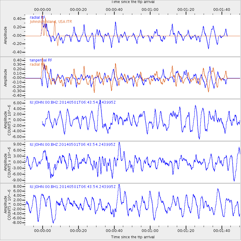
Signal To Noise
| Channel | StoN | STA | LTA |
| IU:JOHN:00:BHZ:20140501T06:43:54.243995Z | 2.7047923 | 3.97879E-6 | 1.471015E-6 |
| IU:JOHN:00:BH1:20140501T06:43:54.243995Z | 2.3953195 | 3.1810066E-6 | 1.3280094E-6 |
| IU:JOHN:00:BH2:20140501T06:43:54.243995Z | 2.0840423 | 3.7411946E-6 | 1.7951625E-6 |
| Arrivals |
| Ps | |
| PpPs | |
| PsPs/PpSs | |


