You are here: Home > Network List > TA - USArray Transportable Network (new EarthScope stations) Stations List
> Station F04D Rainier, OR, USA > Earthquake Result Viewer
F04D Rainier, OR, USA - Earthquake Result Viewer
| Earthquake location: |
Southeast Of Loyalty Islands |
| Earthquake latitude/longitude: |
-21.5/170.2 |
| Earthquake time(UTC): |
2014/05/01 (121) 06:36:37 GMT |
| Earthquake Depth: |
118 km |
| Earthquake Magnitude: |
6.7 MWP, 6.7 MI |
| Earthquake Catalog/Contributor: |
NEIC PDE/NEIC COMCAT |
|
| Network: |
TA USArray Transportable Network (new EarthScope stations) |
| Station: |
F04D Rainier, OR, USA |
| Lat/Lon: |
46.08 N/123.01 W |
| Elevation: |
236 m |
|
| Distance: |
90.4 deg |
| Az: |
39.764 deg |
| Baz: |
238.841 deg |
| Ray Param: |
0.041655947 |
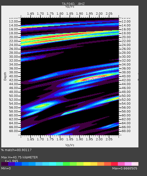
| Estimated Moho Depth: |
40.75 km |
| Estimated Crust Vp/Vs: |
1.97 |
| Assumed Crust Vp: |
6.566 km/s |
| Estimated Crust Vs: |
3.342 km/s |
| Estimated Crust Poisson's Ratio: |
0.33 |
|
| Radial Match: |
80.90117 % |
| Radial Bump: |
400 |
| Transverse Match: |
76.125206 % |
| Transverse Bump: |
400 |
| SOD ConfigId: |
626651 |
| Insert Time: |
2014-05-15 07:16:52.475 +0000 |
| GWidth: |
2.5 |
| Max Bumps: |
400 |
| Tol: |
0.001 |
|

Signal To Noise
| Channel | StoN | STA | LTA |
| TA:F04D: :BHZ:20140501T06:48:54.573982Z | 7.1479683 | 1.4188491E-6 | 1.9849683E-7 |
| TA:F04D: :BHN:20140501T06:48:54.573982Z | 1.0774084 | 4.3964766E-7 | 4.0806034E-7 |
| TA:F04D: :BHE:20140501T06:48:54.573982Z | 1.9255623 | 5.4232964E-7 | 2.8164743E-7 |
| Arrivals |
| Ps | 6.1 SECOND |
| PpPs | 18 SECOND |
| PsPs/PpSs | 24 SECOND |


