You are here: Home > Network List > TA - USArray Transportable Network (new EarthScope stations) Stations List
> Station G05D Wamic, OR, USA > Earthquake Result Viewer
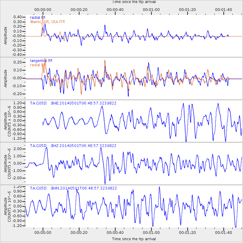
G05D Wamic, OR, USA - Earthquake Result Viewer
*The percent match for this event was below the threshold and hence no stack was calculated.
| Earthquake location: |
Southeast Of Loyalty Islands |
| Earthquake latitude/longitude: |
-21.5/170.2 |
| Earthquake time(UTC): |
2014/05/01 (121) 06:36:37 GMT |
| Earthquake Depth: |
118 km |
| Earthquake Magnitude: |
6.7 MWP, 6.7 MI |
| Earthquake Catalog/Contributor: |
NEIC PDE/NEIC COMCAT |
|
| Network: |
TA USArray Transportable Network (new EarthScope stations) |
| Station: |
G05D Wamic, OR, USA |
| Lat/Lon: |
45.24 N/121.32 W |
| Elevation: |
592 m |
|
| Distance: |
90.9 deg |
| Az: |
41.092 deg |
| Baz: |
240.034 deg |
| Ray Param: |
$rayparam |
*The percent match for this event was below the threshold and hence was not used in the summary stack. |
|
| Radial Match: |
59.250225 % |
| Radial Bump: |
322 |
| Transverse Match: |
62.857475 % |
| Transverse Bump: |
400 |
| SOD ConfigId: |
626651 |
| Insert Time: |
2014-05-15 07:17:06.519 +0000 |
| GWidth: |
2.5 |
| Max Bumps: |
400 |
| Tol: |
0.001 |
|
Signal To Noise
| Channel | StoN | STA | LTA |
| TA:G05D: :BHZ:20140501T06:48:57.323982Z | 5.0387287 | 1.1319822E-6 | 2.2465633E-7 |
| TA:G05D: :BHN:20140501T06:48:57.323982Z | 0.9306932 | 3.8106208E-7 | 4.0943897E-7 |
| TA:G05D: :BHE:20140501T06:48:57.323982Z | 2.2959187 | 5.715579E-7 | 2.489452E-7 |
| Arrivals |
| Ps | |
| PpPs | |
| PsPs/PpSs | |


