You are here: Home > Network List > TA - USArray Transportable Network (new EarthScope stations) Stations List
> Station J05D Fort Rock, OR, USA > Earthquake Result Viewer
J05D Fort Rock, OR, USA - Earthquake Result Viewer

| Earthquake location: |
Southeast Of Loyalty Islands |
| Earthquake latitude/longitude: |
-21.5/170.2 |
| Earthquake time(UTC): |
2014/05/01 (121) 06:36:37 GMT |
| Earthquake Depth: |
118 km |
| Earthquake Magnitude: |
6.7 MWP, 6.7 MI |
| Earthquake Catalog/Contributor: |
NEIC PDE/NEIC COMCAT |
|
| Network: |
TA USArray Transportable Network (new EarthScope stations) |
| Station: |
J05D Fort Rock, OR, USA |
| Lat/Lon: |
43.28 N/121.23 W |
| Elevation: |
1541 m |
|
| Distance: |
90.0 deg |
| Az: |
42.817 deg |
| Baz: |
240.076 deg |
| Ray Param: |
0.041679498 |
| Estimated Moho Depth: |
19.5 km |
| Estimated Crust Vp/Vs: |
1.88 |
| Assumed Crust Vp: |
6.597 km/s |
| Estimated Crust Vs: |
3.5 km/s |
| Estimated Crust Poisson's Ratio: |
0.30 |
|
| Radial Match: |
81.57687 % |
| Radial Bump: |
400 |
| Transverse Match: |
71.70127 % |
| Transverse Bump: |
400 |
| SOD ConfigId: |
626651 |
| Insert Time: |
2014-05-15 07:17:46.582 +0000 |
| GWidth: |
2.5 |
| Max Bumps: |
400 |
| Tol: |
0.001 |
|
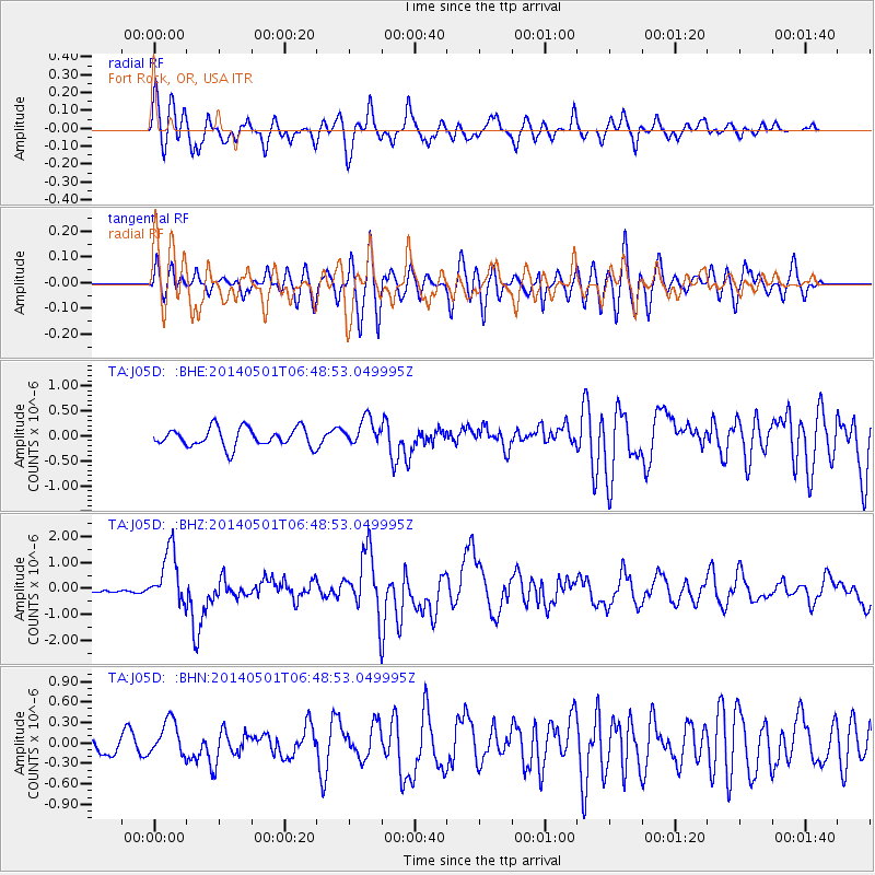
Signal To Noise
| Channel | StoN | STA | LTA |
| TA:J05D: :BHZ:20140501T06:48:53.049995Z | 9.415464 | 1.0578668E-6 | 1.1235418E-7 |
| TA:J05D: :BHN:20140501T06:48:53.049995Z | 1.3353792 | 2.7442556E-7 | 2.0550382E-7 |
| TA:J05D: :BHE:20140501T06:48:53.049995Z | 1.4361547 | 2.6887435E-7 | 1.8721822E-7 |
| Arrivals |
| Ps | 2.7 SECOND |
| PpPs | 8.4 SECOND |
| PsPs/PpSs | 11 SECOND |


