You are here: Home > Network List > TA - USArray Transportable Network (new EarthScope stations) Stations List
> Station S22A 4UR Ranch, Creede, CO, USA > Earthquake Result Viewer
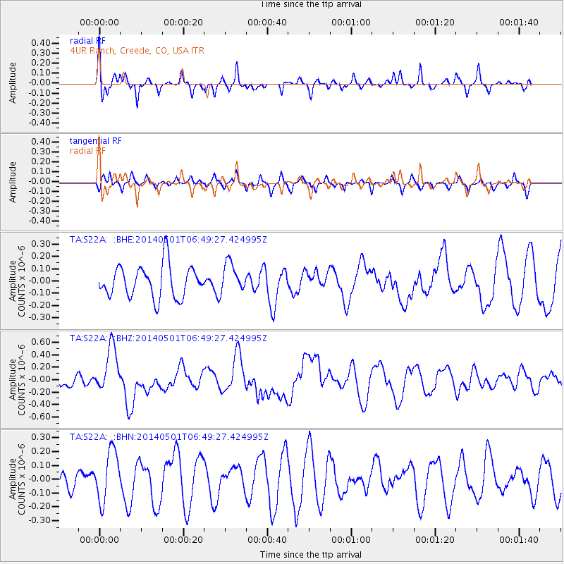
S22A 4UR Ranch, Creede, CO, USA - Earthquake Result Viewer
*The percent match for this event was below the threshold and hence no stack was calculated.
| Earthquake location: |
Southeast Of Loyalty Islands |
| Earthquake latitude/longitude: |
-21.5/170.2 |
| Earthquake time(UTC): |
2014/05/01 (121) 06:36:37 GMT |
| Earthquake Depth: |
118 km |
| Earthquake Magnitude: |
6.7 MWP, 6.7 MI |
| Earthquake Catalog/Contributor: |
NEIC PDE/NEIC COMCAT |
|
| Network: |
TA USArray Transportable Network (new EarthScope stations) |
| Station: |
S22A 4UR Ranch, Creede, CO, USA |
| Lat/Lon: |
37.75 N/106.83 W |
| Elevation: |
2626 m |
|
| Distance: |
97.6 deg |
| Az: |
52.527 deg |
| Baz: |
248.793 deg |
| Ray Param: |
$rayparam |
*The percent match for this event was below the threshold and hence was not used in the summary stack. |
|
| Radial Match: |
68.61882 % |
| Radial Bump: |
337 |
| Transverse Match: |
34.53182 % |
| Transverse Bump: |
261 |
| SOD ConfigId: |
626651 |
| Insert Time: |
2014-05-15 07:18:25.904 +0000 |
| GWidth: |
2.5 |
| Max Bumps: |
400 |
| Tol: |
0.001 |
|
Signal To Noise
| Channel | StoN | STA | LTA |
| TA:S22A: :BHZ:20140501T06:49:27.424995Z | 4.790414 | 3.869402E-7 | 8.077386E-8 |
| TA:S22A: :BHN:20140501T06:49:27.424995Z | 1.4693615 | 1.9127725E-7 | 1.3017711E-7 |
| TA:S22A: :BHE:20140501T06:49:27.424995Z | 0.90126085 | 1.19177194E-7 | 1.3223385E-7 |
| Arrivals |
| Ps | |
| PpPs | |
| PsPs/PpSs | |


