You are here: Home > Network List > UU - University of Utah Regional Network Stations List
> Station KNB Kanab, UT, USA > Earthquake Result Viewer
KNB Kanab, UT, USA - Earthquake Result Viewer
*The percent match for this event was below the threshold and hence no stack was calculated.
| Earthquake location: |
Southeast Of Loyalty Islands |
| Earthquake latitude/longitude: |
-21.5/170.2 |
| Earthquake time(UTC): |
2014/05/01 (121) 06:36:37 GMT |
| Earthquake Depth: |
118 km |
| Earthquake Magnitude: |
6.7 MWP, 6.7 MI |
| Earthquake Catalog/Contributor: |
NEIC PDE/NEIC COMCAT |
|
| Network: |
UU University of Utah Regional Network |
| Station: |
KNB Kanab, UT, USA |
| Lat/Lon: |
37.02 N/112.82 W |
| Elevation: |
1715 m |
|
| Distance: |
92.9 deg |
| Az: |
51.33 deg |
| Baz: |
245.277 deg |
| Ray Param: |
$rayparam |
*The percent match for this event was below the threshold and hence was not used in the summary stack. |
|
| Radial Match: |
65.65988 % |
| Radial Bump: |
303 |
| Transverse Match: |
59.500164 % |
| Transverse Bump: |
400 |
| SOD ConfigId: |
626651 |
| Insert Time: |
2014-05-15 07:20:15.890 +0000 |
| GWidth: |
2.5 |
| Max Bumps: |
400 |
| Tol: |
0.001 |
|
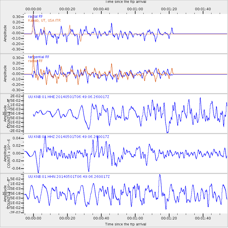
Signal To Noise
| Channel | StoN | STA | LTA |
| UU:KNB:01:HHZ:20140501T06:49:06.260017Z | 5.4630313 | 2.1570147E-8 | 3.9483843E-9 |
| UU:KNB:01:HHN:20140501T06:49:06.260017Z | 0.9843156 | 5.1697957E-9 | 5.2521734E-9 |
| UU:KNB:01:HHE:20140501T06:49:06.260017Z | 4.1462617 | 1.1158183E-8 | 2.691143E-9 |
| Arrivals |
| Ps | |
| PpPs | |
| PsPs/PpSs | |


