You are here: Home > Network List > US - United States National Seismic Network Stations List
> Station ELK Elko, Nevada, USA > Earthquake Result Viewer
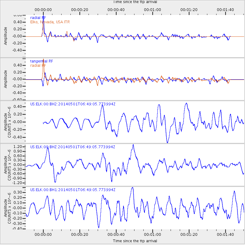
ELK Elko, Nevada, USA - Earthquake Result Viewer
*The percent match for this event was below the threshold and hence no stack was calculated.
| Earthquake location: |
Southeast Of Loyalty Islands |
| Earthquake latitude/longitude: |
-21.5/170.2 |
| Earthquake time(UTC): |
2014/05/01 (121) 06:36:37 GMT |
| Earthquake Depth: |
118 km |
| Earthquake Magnitude: |
6.7 MWP, 6.7 MI |
| Earthquake Catalog/Contributor: |
NEIC PDE/NEIC COMCAT |
|
| Network: |
US United States National Seismic Network |
| Station: |
ELK Elko, Nevada, USA |
| Lat/Lon: |
40.74 N/115.24 W |
| Elevation: |
2210 m |
|
| Distance: |
92.8 deg |
| Az: |
47.153 deg |
| Baz: |
243.972 deg |
| Ray Param: |
$rayparam |
*The percent match for this event was below the threshold and hence was not used in the summary stack. |
|
| Radial Match: |
70.80158 % |
| Radial Bump: |
400 |
| Transverse Match: |
61.019554 % |
| Transverse Bump: |
400 |
| SOD ConfigId: |
626651 |
| Insert Time: |
2014-05-15 07:22:05.908 +0000 |
| GWidth: |
2.5 |
| Max Bumps: |
400 |
| Tol: |
0.001 |
|
Signal To Noise
| Channel | StoN | STA | LTA |
| US:ELK:00:BHZ:20140501T06:49:05.773994Z | 7.8491964 | 5.930182E-7 | 7.555146E-8 |
| US:ELK:00:BH1:20140501T06:49:05.773994Z | 1.7965119 | 1.2145343E-7 | 6.760513E-8 |
| US:ELK:00:BH2:20140501T06:49:05.773994Z | 2.738003 | 2.3125791E-7 | 8.446225E-8 |
| Arrivals |
| Ps | |
| PpPs | |
| PsPs/PpSs | |


