You are here: Home > Network List > GO - National Seismic Network of Georgia Stations List
> Station TBLG Delisi, Georgia > Earthquake Result Viewer
TBLG Delisi, Georgia - Earthquake Result Viewer

| Earthquake location: |
Northern Sumatra, Indonesia |
| Earthquake latitude/longitude: |
1.9/97.9 |
| Earthquake time(UTC): |
2014/05/01 (121) 14:35:38 GMT |
| Earthquake Depth: |
55 km |
| Earthquake Magnitude: |
5.8 MWB |
| Earthquake Catalog/Contributor: |
NEIC PDE/NEIC COMCAT |
|
| Network: |
GO National Seismic Network of Georgia |
| Station: |
TBLG Delisi, Georgia |
| Lat/Lon: |
41.73 N/44.74 E |
| Elevation: |
510 m |
|
| Distance: |
61.9 deg |
| Az: |
317.221 deg |
| Baz: |
114.924 deg |
| Ray Param: |
0.060432415 |
| Estimated Moho Depth: |
14.5 km |
| Estimated Crust Vp/Vs: |
1.83 |
| Assumed Crust Vp: |
6.291 km/s |
| Estimated Crust Vs: |
3.442 km/s |
| Estimated Crust Poisson's Ratio: |
0.29 |
|
| Radial Match: |
88.832825 % |
| Radial Bump: |
400 |
| Transverse Match: |
83.836716 % |
| Transverse Bump: |
400 |
| SOD ConfigId: |
626651 |
| Insert Time: |
2014-05-15 14:55:22.643 +0000 |
| GWidth: |
2.5 |
| Max Bumps: |
400 |
| Tol: |
0.001 |
|
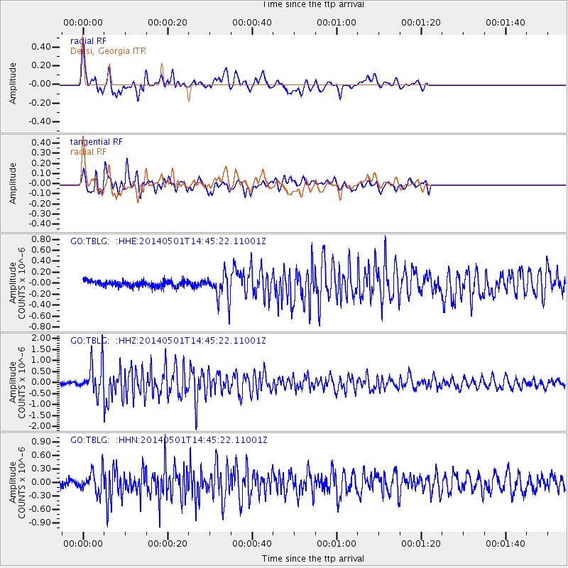
Signal To Noise
| Channel | StoN | STA | LTA |
| GO:TBLG: :HHZ:20140501T14:45:22.11001Z | 13.4866705 | 7.38904E-7 | 5.478773E-8 |
| GO:TBLG: :HHN:20140501T14:45:22.11001Z | 3.881183 | 2.3401034E-7 | 6.029356E-8 |
| GO:TBLG: :HHE:20140501T14:45:22.11001Z | 4.4685473 | 2.3982994E-7 | 5.367067E-8 |
| Arrivals |
| Ps | 2.0 SECOND |
| PpPs | 6.3 SECOND |
| PsPs/PpSs | 8.2 SECOND |


