You are here: Home > Network List > GO - National Seismic Network of Georgia Stations List
> Station TBLG Delisi, Georgia > Earthquake Result Viewer
TBLG Delisi, Georgia - Earthquake Result Viewer
| Earthquake location: |
Seram, Indonesia |
| Earthquake latitude/longitude: |
-3.8/127.4 |
| Earthquake time(UTC): |
2014/05/02 (122) 08:43:37 GMT |
| Earthquake Depth: |
54 km |
| Earthquake Magnitude: |
6.0 MWP |
| Earthquake Catalog/Contributor: |
NEIC PDE/NEIC COMCAT |
|
| Network: |
GO National Seismic Network of Georgia |
| Station: |
TBLG Delisi, Georgia |
| Lat/Lon: |
41.73 N/44.74 E |
| Elevation: |
510 m |
|
| Distance: |
87.1 deg |
| Az: |
311.978 deg |
| Baz: |
97.676 deg |
| Ray Param: |
0.043501947 |
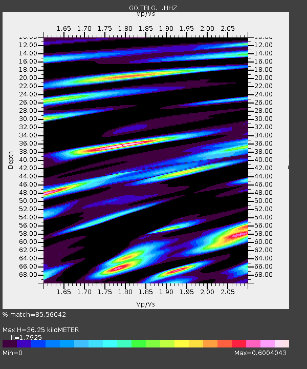
| Estimated Moho Depth: |
36.25 km |
| Estimated Crust Vp/Vs: |
1.79 |
| Assumed Crust Vp: |
6.291 km/s |
| Estimated Crust Vs: |
3.509 km/s |
| Estimated Crust Poisson's Ratio: |
0.27 |
|
| Radial Match: |
85.56042 % |
| Radial Bump: |
390 |
| Transverse Match: |
86.55082 % |
| Transverse Bump: |
400 |
| SOD ConfigId: |
626651 |
| Insert Time: |
2014-05-16 09:04:41.286 +0000 |
| GWidth: |
2.5 |
| Max Bumps: |
400 |
| Tol: |
0.001 |
|

Signal To Noise
| Channel | StoN | STA | LTA |
| GO:TBLG: :HHZ:20140502T08:55:46.079978Z | 12.403846 | 1.166257E-6 | 9.4023825E-8 |
| GO:TBLG: :HHN:20140502T08:55:46.079978Z | 3.233821 | 2.595804E-7 | 8.027049E-8 |
| GO:TBLG: :HHE:20140502T08:55:46.079978Z | 5.5548406 | 3.380582E-7 | 6.0858305E-8 |
| Arrivals |
| Ps | 4.7 SECOND |
| PpPs | 16 SECOND |
| PsPs/PpSs | 20 SECOND |


