You are here: Home > Network List > II - Global Seismograph Network (GSN - IRIS/IDA) Stations List
> Station PFO Pinon Flat, California, USA > Earthquake Result Viewer
PFO Pinon Flat, California, USA - Earthquake Result Viewer
| Earthquake location: |
Vanuatu Islands |
| Earthquake latitude/longitude: |
-19.5/169.2 |
| Earthquake time(UTC): |
1995/06/29 (180) 12:24:03 GMT |
| Earthquake Depth: |
144 km |
| Earthquake Magnitude: |
6.2 MB, 6.7 UNKNOWN, 6.6 MW |
| Earthquake Catalog/Contributor: |
WHDF/NEIC |
|
| Network: |
II Global Seismograph Network (GSN - IRIS/IDA) |
| Station: |
PFO Pinon Flat, California, USA |
| Lat/Lon: |
33.61 N/116.46 W |
| Elevation: |
1280 m |
|
| Distance: |
88.2 deg |
| Az: |
53.494 deg |
| Baz: |
245.338 deg |
| Ray Param: |
0.042406954 |
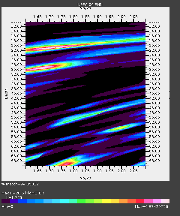
| Estimated Moho Depth: |
20.5 km |
| Estimated Crust Vp/Vs: |
1.73 |
| Assumed Crust Vp: |
6.264 km/s |
| Estimated Crust Vs: |
3.631 km/s |
| Estimated Crust Poisson's Ratio: |
0.25 |
|
| Radial Match: |
94.85822 % |
| Radial Bump: |
355 |
| Transverse Match: |
84.887985 % |
| Transverse Bump: |
400 |
| SOD ConfigId: |
61242 |
| Insert Time: |
2010-03-01 21:37:50.474 +0000 |
| GWidth: |
2.5 |
| Max Bumps: |
400 |
| Tol: |
0.001 |
|
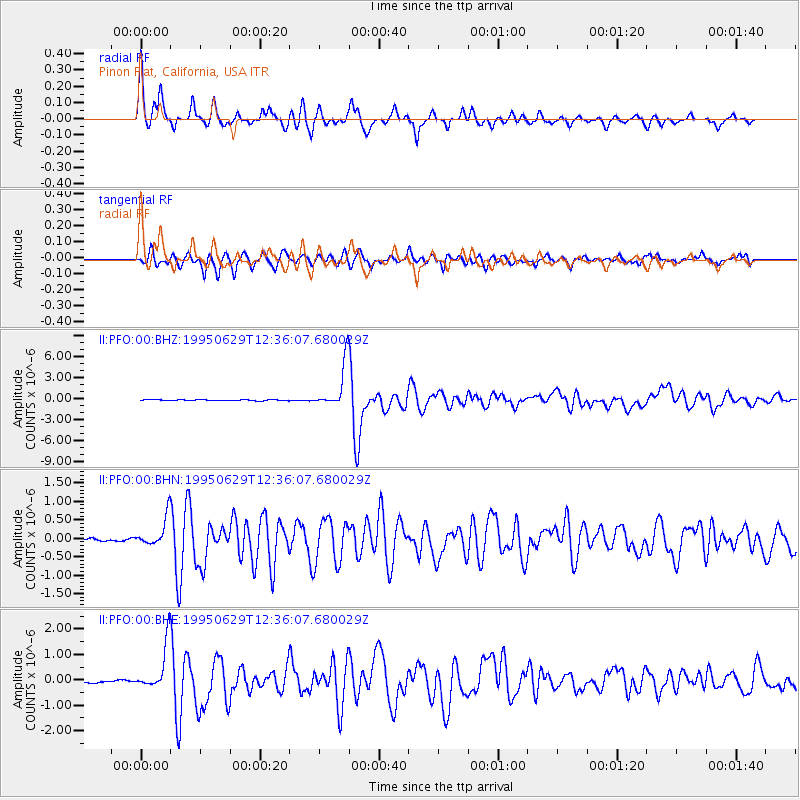
Signal To Noise
| Channel | StoN | STA | LTA |
| II:PFO:00:BHN:19950629T12:36:07.680029Z | 9.1941185 | 3.9240138E-7 | 4.2679606E-8 |
| II:PFO:00:BHE:19950629T12:36:07.680029Z | 13.6817255 | 9.0752224E-7 | 6.6330976E-8 |
| II:PFO:00:BHZ:19950629T12:36:07.680029Z | 42.865726 | 3.1774548E-6 | 7.4125765E-8 |
| Arrivals |
| Ps | 2.4 SECOND |
| PpPs | 8.7 SECOND |
| PsPs/PpSs | 11 SECOND |


