You are here: Home > Network List > KN - Kyrgyz Seismic Telemetry Network Stations List
> Station ULHL - > Earthquake Result Viewer
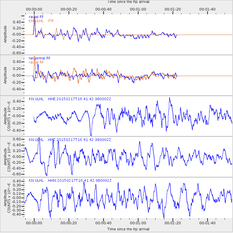
ULHL - - Earthquake Result Viewer
*The percent match for this event was below the threshold and hence no stack was calculated.
| Earthquake location: |
Off East Coast Of Honshu, Japan |
| Earthquake latitude/longitude: |
39.6/143.6 |
| Earthquake time(UTC): |
2015/02/17 (048) 16:33:21 GMT |
| Earthquake Depth: |
10 km |
| Earthquake Magnitude: |
5.5 MWW, 5.5 MWC, 5.5 MWB |
| Earthquake Catalog/Contributor: |
NEIC PDE/NEIC COMCAT |
|
| Network: |
KN Kyrgyz Seismic Telemetry Network |
| Station: |
ULHL - |
| Lat/Lon: |
42.25 N/76.24 E |
| Elevation: |
2040 m |
|
| Distance: |
49.7 deg |
| Az: |
296.135 deg |
| Baz: |
69.148 deg |
| Ray Param: |
$rayparam |
*The percent match for this event was below the threshold and hence was not used in the summary stack. |
|
| Radial Match: |
67.14349 % |
| Radial Bump: |
371 |
| Transverse Match: |
75.59808 % |
| Transverse Bump: |
400 |
| SOD ConfigId: |
7019011 |
| Insert Time: |
2019-04-16 21:46:09.968 +0000 |
| GWidth: |
2.5 |
| Max Bumps: |
400 |
| Tol: |
0.001 |
|
Signal To Noise
| Channel | StoN | STA | LTA |
| KN:ULHL: :HHZ:20150217T16:41:42.980002Z | 1.9179968 | 2.8653963E-7 | 1.4939526E-7 |
| KN:ULHL: :HHN:20150217T16:41:42.980002Z | 0.8662568 | 1.3588651E-7 | 1.5686632E-7 |
| KN:ULHL: :HHE:20150217T16:41:42.980002Z | 2.6594427 | 2.2817858E-7 | 8.579939E-8 |
| Arrivals |
| Ps | |
| PpPs | |
| PsPs/PpSs | |


