You are here: Home > Network List > II - Global Seismograph Network (GSN - IRIS/IDA) Stations List
> Station PFO Pinon Flat, California, USA > Earthquake Result Viewer
PFO Pinon Flat, California, USA - Earthquake Result Viewer

| Earthquake location: |
Near Coast Of Central Chile |
| Earthquake latitude/longitude: |
-30.9/-71.2 |
| Earthquake time(UTC): |
1997/10/15 (288) 01:03:33 GMT |
| Earthquake Depth: |
58 km |
| Earthquake Magnitude: |
6.8 MB, 6.8 MS, 7.3 UNKNOWN, 7.1 MW |
| Earthquake Catalog/Contributor: |
WHDF/NEIC |
|
| Network: |
II Global Seismograph Network (GSN - IRIS/IDA) |
| Station: |
PFO Pinon Flat, California, USA |
| Lat/Lon: |
33.61 N/116.46 W |
| Elevation: |
1280 m |
|
| Distance: |
77.1 deg |
| Az: |
322.565 deg |
| Baz: |
141.253 deg |
| Ray Param: |
0.050434783 |
| Estimated Moho Depth: |
28.0 km |
| Estimated Crust Vp/Vs: |
1.61 |
| Assumed Crust Vp: |
6.264 km/s |
| Estimated Crust Vs: |
3.89 km/s |
| Estimated Crust Poisson's Ratio: |
0.19 |
|
| Radial Match: |
96.70348 % |
| Radial Bump: |
400 |
| Transverse Match: |
92.41675 % |
| Transverse Bump: |
400 |
| SOD ConfigId: |
9875 |
| Insert Time: |
2010-03-01 21:39:47.166 +0000 |
| GWidth: |
2.5 |
| Max Bumps: |
400 |
| Tol: |
0.001 |
|
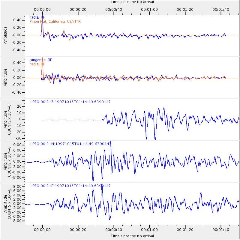
Signal To Noise
| Channel | StoN | STA | LTA |
| II:PFO:00:BHN:19971015T01:14:49.639014Z | 2.4800162 | 3.600597E-7 | 1.451844E-7 |
| II:PFO:00:BHE:19971015T01:14:49.639014Z | 1.3507849 | 1.8218384E-7 | 1.3487258E-7 |
| II:PFO:00:BHZ:19971015T01:14:49.639014Z | 2.064765 | 4.321732E-7 | 2.0930865E-7 |
| Arrivals |
| Ps | 2.8 SECOND |
| PpPs | 11 SECOND |
| PsPs/PpSs | 14 SECOND |


